
IMPORTANT PASSES OF INDIA// IMPORTANT FOR NET/PSC/WBSC/SSC/WBSET/PGT/TGT
Table of Contents
Major Passes in India

Passes
of the Western Himalayas

1) Jammu and
Kashmir

1.1)Mintaka Pass
1.2)Parpik Pass
1.3)Khunjerab Pass
1.4)Aghil Pass
1.5)Banihal Pass
1.6)Chang-La
1.7)Khardung La
1.8)Lanak La
1.9)Pir-Panjal pass
1.10)Qara Tag La
1.11)Imis La
1.12)Pensi La
1.13) Zoji La
1.14) Babusar pass
2)Himachal
Pradesh

2.1)Bara Lacha La
2.2)Debsa Pass
2.3)Rohtang Pass
2.4) Shipki La
2.5) Raniso pass
2.6) Khimokul pass
3)Uttarakhand

3.1)Lipu Lekh
3.2)Mana Pass
3.3)Mangsha Dhura
3.4)Niti Pass
3.5)Muling La
Passes
of the Eastern Himalayas
Sikkim.

1.1)Nathu La
1.2)Jelep La
Arunachal
Pradesh

2.1)Bom Di La
2.2)Dihang Pass
2.3)Yonggyap Pass
2.4)Dipher Pass
2.5)Kumjawng Pass
2.6)Hpungan Pass
2.7) Chankan Pass
Mountain Passes in the Deccan Plateau in India
3.1) Goram Ghat
3.2) Haldighati Pass
3.3) Asirgarh Pass
3.4) Palakkad Gap
3.5) Bhor Ghat
3.6) Thal Ghat
INTRODUCTION:-
A mountain pass is a navigable route through a
mountain range or over a ridge. Passes have played a key role in trade, war,
and both human and animal migration throughout history.Mountain Passes are
often found just above the source of a river, constituting a drainage divide. A
pass may be very short, consisting of steep slopes to the top of the pass, or
maybe a valley many kilometers long.
MAJOR MOUNTAIN PASSES IN INDIA
|
Mountain passes in
western Himalaya |
||
|
State/UTs: Jammu and Kashmir |
||
|
Name of Passes |
Location |
Feature |
|
1.1)Mintaka Pass |
Kashmir and china |
Trijunction of India-China and
Afghanistan border |
|
1.2)Parpik Pass |
Kashmir and china |
Situated in East of Mintaka pass |
|
1.3)Khunjerab Pass |
Kashmir and china |
Indo-China border |
|
1.4)Aghil Pass |
Ladakh in India with the Xinjiang
(Sinkiang) Province of China |
North of K2 Peak (the highest peak in
India and the second highest peak in the world) it locates at 5000 m from sea level |
|
1.5)Banihal Pass |
Jammu and Srinigar |
·
It situates at
2832 m ·
It lies across
the Pir-Panjal Range ·
It remains
snow covered during winter season |
|
1.6)Chang-La |
Ladakh with Tibet |
It lies at the altitude of 5360 m |
|
1.7)Khardung La |
Jammu and Kashmir near leh |
It lies at the altitude of 5602 m The world’s highest motor able road
passes through this pass |
|
1.8)Lanak La |
India and China |
This pass provides passage between
Ladak and Lhasa. A road to connect Xinjiang Province with Tibet has been
constructed by the Chinese |
|
1.9)Pir-Panjal pass |
|
Provides the shortest and the easiest
metal road between Jammu and Kashmir Valley. But this route had to be closed
down as a result of partition of the subcontinent |
|
1.10)Qara Tag La |
Indo-China borer across the Karakoram
Range |
It is located in the Karakoram
Mountains. It was a subsidiary of the ancient silk route. |
|
1.11)Imis La |
|
The pass has a difficult geographical
terrain and steep slopes. This pass remains closed during the winter season.
It connects Ladakh and Tibet |
|
1.12)Pensi La |
link between the Kashmir Valley and
Kargil |
The Pensi La connects the Kashmir
valley with Kargil. It is situated in the Greater Himalayas. |
|
1.13) Zoji La |
between Srinagar on one side and
Kargil and Leh on the other side |
It connects Srinagar with Kargil and
Leh. Beacon Force of Border Road Organization is responsible for clearing and
maintaining the road, especially during the winter. |
|
1.14) Bara-La/ Bara- Lacha La |
Manali and Leh |
It is situated on the National Highway
in the state of Jammu and Kashmir. It connects Manali and Leh. |
|
State: Himachal Pradesh |
||
|
2.1)Bara Lacha La |
Manali and Leh |
It is situated on the National Highway
in the state of Jammu and Kashmir. It connects Manali and Leh. |
|
2.2)Debsa Pass |
Spiti Valley and Parvati Valley |
It joins Spiti Valley and Parvati
Valley. It is a high mountain pass in between the Kullu and Spiti of Himachal
Pradesh. It is a bypass route of Pin-Parvati Pass. |
|
2.3)Rohtang Pass |
Sptiti , Kullu and Lahul |
This is located in the state of
Himachal Pradesh. It has excellent road transportation. This pass connects
Kullu, Spiti and Lahul. |
|
2.4) Shipki La |
Himachal Pradesh and Tibet |
It is located through Sutlej Gorge. It
connects Himachal Pradesh with Tibet. It is India’s third border post for
trade with China after Lipu Lekh and Nathula Pass. |
|
2.5) Raniso pass |
Himachal Pradesh and Tibet |
|
|
2.6) Khimokul pass |
Himachal Pradesh and Tibet |
|
|
State :Uttarakhand |
||
|
3.1)Lipu Lekh |
Uttarakhand and Tibet |
It is located in Uttarakhand. It
connects Uttarakhand with Tibet. This pass is an important border post for
trade with China. The pilgrims for Manasarovar travel through this pass. |
|
3.2)Mana Pass |
Uttarakhand and Tibet |
It is located in the Greater Himalayas
and connects Tibet with Uttarakhand. It remains under snow for six months
during winter. |
|
3.3)Mangsha Dhura |
Uttarakhand and Tibet |
The pass which connects
Uttarakhand-Tibet is known for landslides. The pilgrims for Manasarovar cross
this route. It’s located in the Kuthi Valley. |
|
3.4)Niti Pass |
Uttarakhand and Tibet |
This pass joins Uttarakhand with
Tibet. This also remains snow-covered during the winter season. |
|
3.5)Muling La |
Uttarakhand and Tibet |
It is situated in the north of
Gangotri, at an elevation of 5669 m in the Great Himalayas. This seasonal
pass that connects Uttarakhand with Tibet remains snow-covered during the
winter season. |
|
|
||
|
Passes of the Eastern
Himalayas |
||
|
Sikkim |
||
|
1.1)Nathu La |
Sikkim with Tibet |
It is located in the state of Sikkim.
This famous pass is located in the India- China border and was reopened in
2006. It forms a part of an offshoot of the ancient silk route. It is one of
the trading border posts between India and China. |
|
1.2)Jelep La |
Sikkim-Bhutan border |
This pass passes through the Chumbi
valley. It connects Sikkim with Lhasa, the capital of Tibet. |
|
State: Arunachal Pradesh |
||
|
2.1)Bom Di La |
Arunachal Pradesh with Bhutan |
The Bomdi-La pass connects Arunachal
Pradesh with Lhasa, the capital city of Tibet. It is located in the east of
Bhutan. |
|
2.2)Dihang Pass |
Arunachal Pradesh- Mandalay(Myanmar) |
It is located in the Northeastern
states of Arunachal Pradesh. This pass connects Arunachal Pradesh with
Myanmar (Mandalay). At an elevation of more than 4000 m, it provides passage. |
|
2.3)Yonggyap Pass |
Arunachal Pradesh with Tibet |
|
|
2.4)Dipher Pass |
India, China and Myanmar |
Easy access between Arunachal Pradesh
and Mandalay in Myanmar. It is an important land trade route between India
and Myanmar and remains open throughout the year. |
|
2.5)Kumjawng Pass |
Arunachal Pradesh with Myanmar |
|
|
2.6)Hpungan Pass |
Arunachal Pradesh with Myanmar |
|
|
2.7) Chankan Pass |
Arunachal Pradesh with Myanmar |
|
|
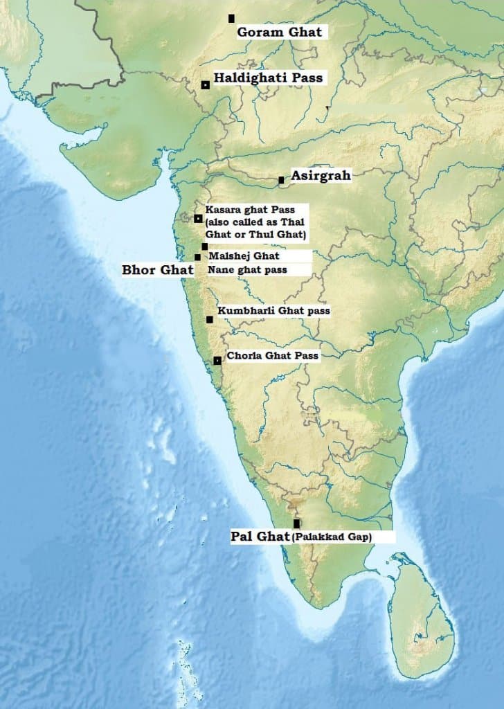
Mountain Passes in the
Deccan Plateau in India |
||
|
3.1) Goram Ghat |
Mewar and Marwar in Rajasthan through
the Aravali Hills |
Goram Ghat is located in the Aravali
Range in the state of Rajasthan, India at an elevation of about 900 m. Goram
Ghat connects Mewar and Marwar in Rajasthan through the Aravali Hills |
|
3.2) Haldighati Pass |
the Aravali Range in the state of
Rajasthan, |
Haldighati Pass is located in the
Aravali Range in the state of Rajasthan,
India at an elevation of about 396 m. The name Haldighati is derived from the
turmeric (‘haldi’ in hindi) coloured soil in the mountain pass. |
|
3.3) Asirgarh Pass |
The Asirgarh Pass connects the Narmada
and Tapti Valleys. |
Asirgarh Pass is located in the
Satpura Range in the state of Madhya Pradesh, India at an elevation of about
260 m. The Asirgarh Pass connects the Narmada and Tapti Valleys and is also
known as the ‘Key to the Deccan’ for being among the most important routes
from northern India to the Deccan. |
|
3.4) Palakkad Gap |
Western Ghats between the states of
Tamil Nadu and Kerala |
The Palakkad Gap is located in the
Western Ghats between the states of Tamil Nadu and Kerala. India at an
elevation of about 140 m. The mountain pass is located between Nilgiri Hills
in the north and Anaimalai Hills towards the south and connects Coimbatore in
Tamil Nadu with Palakkad in Kerala. |
|
3.5) Bhor Ghat |
Palasdari and Khandala |
Bhor Ghat or Bor Ghat or Bhore Ghaut
is a mountain passage located between Palasdari and Khandala for railway and
between Khopoliand Khandala on the road route in Maharashtra, India situated
on the crest of the Western Ghats |
|
3.6) Thal Ghat |
Western Ghats near the town of Kasara
in Maharashtra. |
Thal Ghat (also called Thul Ghat or
Kasara Ghat) is a ghat section (mountain incline or slope) in the Western
Ghats near the town of Kasara in Maharashtra. |
Sayantani Singh
SAYANTANI SINGH Msc, B.Ed
GEOGRAPHIA
If you want to join my telegram group

GEOLOGICAL TIME SCALE IN BENGALI CLICK HERE .
পৃথিবীর অন্দরমহলের বর্ননা click here
interior structure of the earth click here
KANT GASEOUS HYPOTHESIS CLICK HERE
কান্টের গ্যাসীয় মতবাদ CLICK HERE
Free note for REMOTE SENSING AND GIS CLICK HERE
Regional planning in india click here
NCERT CLASS_6 SHORT NOTE CLICK HERE
NCERT CLASS _6 SOLUTION CLICK HERE
ICSE class -ix click here
ICSE class -x click here
CLASS 6 WBBSE GEOGRAPHY CLICK HERE
জলবায়ুর শ্রেণীবিভাগপ্রশ্ন-উত্তর click here
REGIONAL THEORIES CLICK HERE
দ্বাদশ শ্রেণী ভূগোল CLICK HERE
CURRENT AFFAIRS CLICK HERE
NOTES OF HUMAN GEOGRAPHY AND AND POPULATION GEOGRAPHY click here
CONTINENTAL DRIFT THEORY BY FB TAYLOR CLICK HERE
CONTINENTAL DRIFT THEORY BY TAYLOR IN BENGALI CLICK HERE
CONTINENTAL DRIFT THEORY BY WEGNER CLICK HERE
CLIMATE OF INDIA CLICK HERE
ভূমিরূপ গঠন কারী প্রক্রিয়া ; উচ্চমাধ্যমিক ভূগোল click here
বহির্জাত প্রক্রিয়া ও তার ফলে সৃষ্ট ভূমিরূপ click here
মহিসঞ্চারন তত্ত্ব click here
Ugc net 2007 june paper 2 geography click here
Ugc net 2006 december paper 2 geography click here
UGC NET GEOGRAPHY 2007 DECEMBER CLICK HERE
UGC NET GEOGRAPHY 2008 JUNE CLICK HERE
WB CLASS 6 GEOGRAPHY CHAPTER 4 CLICK HERE
UGC NET GEOGRAPHY 2009 JUNE CLICK HERE
PLATE TECTONIC THEORY CLICK HERE
NCERT CLASS 7 GEOGRAPHY CLICK HERE
CORAL REEF IN BENGALI NOTE CLICK HERE
CORAL REEF CLICK HERE
HS GEOGRAPHY CLICK HERE
COASTAL INDIA CLICK HERE
WBBSE CLASS 8 GEOGRAPHY CLICK HERE
NCERT CLASS 8 GEOGRAPHY CLICK HERE
NCERT CLASS 8 GEOGRAPHY CHAPTER 1 RESOURCE CLICK HERE
GEOGRAPHICAL TERMS CLICK HERE
RIVER SYSTEM IN WEST BENGAL CLICK HERE
Thank you for visiting this page.we provide geography related study materials on daily basis..


.png)

.png)

.png)


0 Comments