
River system in west Bengal

welcome to geographia_WWW.GEOGRAPHIA97.BLOGSPOT.COM.WE ARE HERE PROVIDED THE STUDY MATERIALS OF GEOGRAPHY IN VARIOUS TOPICS. TODAYS TOPIC IS RIVER SYSTEM IN WEST BENGAL .IT IS VERY IMPORTANT FOR WBCS, SSC AND OTHER COMPETITIVE EXAMINATION
Basic Terminology of
River
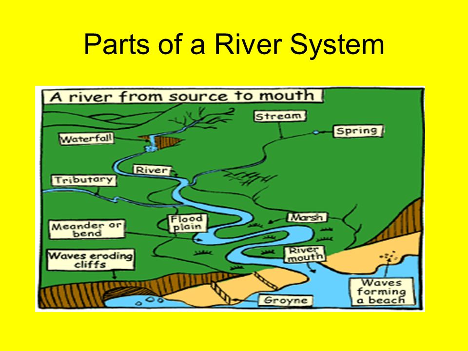
The
study of rivers is known as Potamology.
River: A
river is a naturally winding watercourse that drains surplus water from a
drainage basin.
River channels: The trenches in which rivers flow for most of the year.
Tributary: A stream or river which flows into another river. The
place at which the two rivers join is known as the confluence.
Distributary: A distributary is a river which branches off from the
main river to merge into the sea. A distributary is the opposite of tributary.
Distributaries are common feature at the deltas.
Reservoir: A reservoir is an artificial lake created by building a
dam across a river.
Dam: A
dam is an artificial barrier built across a river with the purpose of storing
water to be utilized for generation of electricity, irrigation etc.
Brackish waters: Water which is saltier than river water but less salty
than sea water.
Delta: It
is a triangular tract of deposits at the mouth of a river. It is composed of
sands, silts and clay deposited by river water and is extremely productive
agriculturally. Bird's Foot, Cuspate and Arcuate (fan-shaped) are the types of
delta depending on the shape the river creates.
Estuary: It
is the place where river meets the sea, also called the mouth of the river.
DRAINAGE SYSTEM IN WEST BENNGAL

Drainage systems, also known as river systems, are the patterns formed by the
streams, rivers, and lakes in a particular drainage basin. They are governed by
the topography of the land, whether a particular region is dominated by hard or
soft rocks and the gradient of the land. The
state of West Bengal, a land of many rivers. The
state has been divided into 23 districts, the seven districts are within North
Bengal and remaining 15 districts are in South Bengal. West Bengal is the only
state of India that extends from the Himalaya in the north to Bay of Bengal in
south. It offers wide topographic diversity and intricate drainage network of
29 basins. The south Bengal can further be subdivided into two geographical
units taking Bhagirathi-Hugli River (the western distributaries of the Ganga)
as the demarcating line. The western part is called Rarh Bengal and the eastern
part is described deltaic Bengal.

The
state can be demarcated into three distinct drainage basins coming under the
Ganga, Brahmaputra, and Subarnarekha systems respectively.
The
area-wise distributions of the above main basins in the state are as under:–
·
Ganga Basin
including Sundarban Area (74, 732 sq.km)
·
Brahmaputra Basin
(11, 860 sq.km)
·
Subarnarekha Basin
(2,160 sq. km)
Ganga Basin including Sundarban Area (74, 732 sq.km)

·
The Ganga system
comprises a total area of 74,732 sq. km, within the state of West Bengal.
·
length: The total
length of the river Ganga from its point of origin to the point where it falls
into sea is about 2575 km (measured along Bhagirathi and the Hooghly), of which
1450 km lies in Uttaranchal and Uttar Pradesh, 110 km along with Uttar Pradesh
and Bihar border, 445 km in Bihar and 570 km in West Bengal.
·
The two holy rivers – Bhagirathi and Alakananda originating
from the glaciers of the Himalayas at an altitude of 7000 M. join at Dev Prayag and the combined stream is known as the Ganga.
·
It emerges into the plains at Rishikesh in Uttaranchal.
·
After flowing exclusively
through Uttaranchal and Uttar Pradesh it receives the flow of Yamuna, the
largest tributary at Allahabad.
·
The Ganga forms the boundary
between Uttar Pradesh and Bihar for a length of about 110 km. and the river
then enters Bihar and flows more or less through the middle of the state.
·
After its confluence with the
Kosi, the Ganga continues its eastward flows in Bihar for about 40 km, and then
it enters West Bengal.
·
As it enters West Bengal, the
river swings around the Rajmahal hill range and then starts flowing almost due south.
·
The river then bifurcates into
two arms about 40 km. below Farakka.
·
The left-arm called the Padma flows
eastwards into Bangladesh while the right arm called Bhagirathi continues to flow south through West Bengal.
·
The stretch of the river after Nabadwip is called Hooghly and
ultimately outfalls into the Bay of Bengal near Sagar Island.
Mahananda
The river Mahananda originates from Ghoom
near Darjeeling town in the district of Darjeeling.
The river bifurcates into two channels at
Barsoi in Bihar.
Out of the two branches, one flows through
Bihar by the name Fulahar and the other flows through West Bengal as Mahananda.
The river Mahananda carrying the flow of four
tributaries namely, Nagar, Kalindri, Tangon, and Punarbhaba, drains into the
river Ganga from the North-Western side at Godogarighat just downstream of the
point where Ganga leaves the boundary of West Bengal.
Jalangi- Bhairab
The river Jalangi originates from the right
bank of the river Padma in Murshidabad district, 165 km. downstream of Farakka.
Jalangi is dead for all purposes except
during the periods of rain when it receives water from the Padma.
The river ends its journey by finally
outfalling into the river Hooghly near Nabadwip town in Nadia district in West
Bengal.
The river Bhairab starts its journey from the
river Ganga in P.S. Lalbag of Murshidabad district.
It is now almost a dead channel but during
the rainy season, it receives water from the Padma.
Ichamati- Churni
The river Mathabhanga originates from the
mouth of the Jalangi of Padma.
It is not an important river in this stage,
as it flows mainly through Bangladesh. It flows only a few kilometers within
the district of Nadia.
At this stage, the river bifurcates into two
streams – the eastern course runs a few kilometers through the districts in a
south-east direction to meet Bhagirathi by the name Churni and the other course
flows by the name Ichamati.
Ichamati gets a little supply from the Padma
and thrives on washout by tidal flows
Bhagirathi- Hooghly
The Ganga Brahmaputra Meghna river system
constitutes one of the largest river systems in the world in terms of its water
resources.
The river Ganga originating in the Himalayas
in India drains a vast area. Near its deltaic head at Farakka it divides into
two channels, the Bhagirathi-Hooghly and the Padma.
The Bhagirathi-Hooghly flows through West
Bengal and outfalls in the Bay of Bengal and the Padma crosses over into
Bangladesh and joins the Brahmaputra at Goalundo.
The river Bhagirathi divides the Murshidabad
district into two parts. It receives three right bank tributaries namely the
Bagmari-Pagla, the Mayurakshi, and the Ajoy.
It receives the Jalangi just upstream of
Nabadwip town from the left. After its confluence with the Jalangi, the
Bhagirathi is known as the Hooghly.
The Bhagirathi-Hooghly is the main river in
the state and is the main drainage artery for the southern districts draining
almost the entire area.
Before the 12th century, the Ganga had its
main course down Bhagirathi-Hooghly. Subsequently, the main flow was pushed to
the east through the present course of Padma.
The flow of Bhagirathi increases downstream
due to the runoff and outflows receives from a number of eastern and western
tributaries.
It also forms the boundary between
24-Parganas and Hooghly districts.
Mayurakshi- Babla
Mayurakshi originates from the high lands of
Santhal Parganas.
It is the main river of the Birbhum district.
Several spill channels – the Manikarnika, Kana Mor, Gambhira, etc. take off
from the Mayurakshi in its lower reaches.
All these rivers flow into the lower pocket
of Hijal Beel in the district of Murshidabad.
From the Beel, the river Babla starts its
journey finally draining into the river Bhagirathi.
The drainage and flood level in the Hijal
Beel is considerably influenced by the level ruling in the Bhagirathi.
Ajoy
The river Ajoy originates from the hills near
Deoghar in Jharkhand.
The principal tributaries of the river are –
Hinghlow, Kunoor, Pathro, and Jayanti.
Damodar
The river Damodar originating from Palamau
hills in Jharkhand and bifurcates into two channels at Beguahana.
The main flow passes through the Mundeswari
channel and discharges into Rupnarayan.
The other one Amta channel carries discharge
during high floods and outfalls into the Hooghly.
Dwarakeswar-Silabati-Rupnarayan
Dwarakeswar originates from the high lands of
Purulia district.
River Ganddheswari rising from Bankura
district meets Dwarakeswar near Bankura town receiving water from streams like
Arkasha, Berai, enters Hooghly district and meets Silabati to form Rupnarayan.
Silabati also originates in the Purulia district.
It traverses through the district of
Midnapore.
The river receives the water of Joypanda and
meets with Dwarakeswar to form Rupnarayan. Rupnarayan is a combination of a
number of streams.
The tidal reach below the confluence of
Dwarakeswar and Silabati is known as Rupnarayan.
It outfalls into Hooghly after receiving the
main flow of Damodar through Mundeswari and the branch of Kangsabati.
The river is tidal throughout its entire
course.
Kangsabati-Kaliaghai-Haldi
The river Kangsabati originating from Purulia
district is joined by Kumari in Bankura district.
Further down, it is joined by the combined
streams of Bhairab Banki and Tarafeni rivers and thereafter it flows through
the Midnapore district. After a tortuous course, it bifurcates.
The upper branch is known as old Cossye or
Palaspai Khal outfalls into the Rupnarayan and the other one is known as New
Cossye.
The river Kaliaghai trickles out from
Jhargram, P.S. in the Midnapore district. During the course of its journey, it
is fed by the flow of its tributaries namely Kapaleswari, Baghai, and Chandia.
This combined flow meets the other arm of
Kangsabati i.e. New Cossye to form Haldi.
The river Haldi formed by the joining of New
Cossye and the combined flow of Kaliaghai outfalls into the river Hooghly. The
lower portion of the river Haldi is affected by over bank spills and drainage
problems during the monsoon.
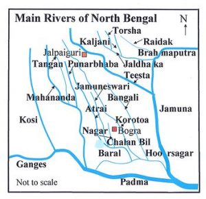
Brahmaputra Basin Drainage System

This system consists of a total area of 11,
860 sq. km. Nearly 14% of the geographical area of the state.
This basin area is interspersed with a large
number of drainage channels that join the main drainage arteries of the regions
like the rivers Teesta, Torsa, Raidak, Mansai, Jaldhaka etc.
All these rivers originate from the Himalayas
in Bhutan/Sikkim and flow across the Terai region and reach the plains of West
Bengal and then flow to Bangladesh joining ultimately the Brahmaputra in
Bangladesh.
Brahmaputra rivers system
Sankosh:
·
It is the eastern most river of the Brahmaputra river which is
originated in Bhutan
·
It serves as boundary between two state west Bengal and Assam.
·
It joins with Raidak-ii and
finally fall into Brahmaputra in Bangladesh by the name of Gangadhar.
Raidak:
·
it is originated in Mt.Akhungphu at the altitude of 6400 meters in
Bhutan
·
the river bifurcates into two branches i.e Raidak – I and Raidak- II
at bhutanghat , close into Indo – Bangladesh boarder
·
raidak –I joins at the united stream of Torsa and kaljani and Raidak
– ii joins in sankosh
·
Both rivers fall into Bangladesh with the name of gangadhar.
Torsa:
·
The river Torsa originates in chumby valley at southern Tibet at
altitude of 7065 m.
·
It flows through Tibet, Bhutan, West Bengal and Bangladesh.
·
Below Harimara bridge in NH – 31 and bifurcates into two channels –
sil torsa and char torsa. They re-join in patla khowa forest.
·
The river passes by coochbihar town and joined by kaljani and raidak
– I.
·
The combined flow outfalls into Brahmaputra near Nageswer at rangpur
in Bangladesh
Jaldhaka:
·
The river jaldhaka originates in Bitang Lake in Sikkim at the
altitude of 4400 km.
·
It flows through west Bengal, Bhutan, Sikkim and Bangladesh.
·
After that river joins into many tributaries and distributaries in
mountainous and sub mountainous region.
·
The combine flow of river outfalls into Brahmaputra in Bangladesh.
Teesta
·
the mighty river of North Bengal Originates in the glacier of north
Sikkim at the altitude of 6400m and formed by two stream i.e lachen and lachung
·
they enter into west Bengal at rangpoo and at mechi
·
it forms as boundary between west Bengal and Sikkim
·
two tributaries are great rangit and ramman
·
The combine flow of river outfalls into Brahmaputra in Bangladesh.

SAYANTANI SINGH Msc, B.Ed
GEOGRAPHIA
If you want to join my telegram group
YOU TUBE CHANNEL LET'S LEARN GEOGRAPHY click here
NCERT CLASS_6 SHORT NOTE CLICK HERE
NCERT CLASS _6 SOLUTION CLICK HERE
ICSE class -ix click here
ICSE class -x click here
CLASS 6 WBBSE GEOGRAPHY CLICK HERE
জলবায়ুর শ্রেণীবিভাগপ্রশ্ন-উত্তর click here
REGIONAL THEORIES CLICK HERE
দ্বাদশ শ্রেণী ভূগোল CLICK HERE
CURRENT AFFAIRS CLICK HERE
NOTES OF HUMAN GEOGRAPHY AND AND POPULATION GEOGRAPHY click here
CONTINENTAL DRIFT THEORY BY FB TAYLOR CLICK HERE
CONTINENTAL DRIFT THEORY BY TAYLOR IN BENGALI CLICK HERE
CONTINENTAL DRIFT THEORY BY WEGNER CLICK HERE
CLIMATE OF INDIA CLICK HERE
ভূমিরূপ গঠন কারী প্রক্রিয়া ; উচ্চমাধ্যমিক ভূগোল click here
বহির্জাত প্রক্রিয়া ও তার ফলে সৃষ্ট ভূমিরূপ click here
মহিসঞ্চারন তত্ত্ব click here
Ugc net 2007 june paper 2 geography click here
Ugc net 2006 december paper 2 geography click here
UGC NET GEOGRAPHY 2007 DECEMBER CLICK HERE
UGC NET GEOGRAPHY 2008 JUNE CLICK HERE
WB CLASS 6 GEOGRAPHY CHAPTER 4 CLICK HERE
UGC NET GEOGRAPHY 2009 JUNE CLICK HERE
PLATE TECTONIC THEORY CLICK HERE
NCERT CLASS 7 GEOGRAPHY CLICK HERE
CORAL REEF IN BENGALI NOTE CLICK HERE
CORAL REEF CLICK HERE
HS GEOGRAPHY CLICK HERE
Thank you for visiting this page.we provide geography related study materials on daily basis..


0 Comments