
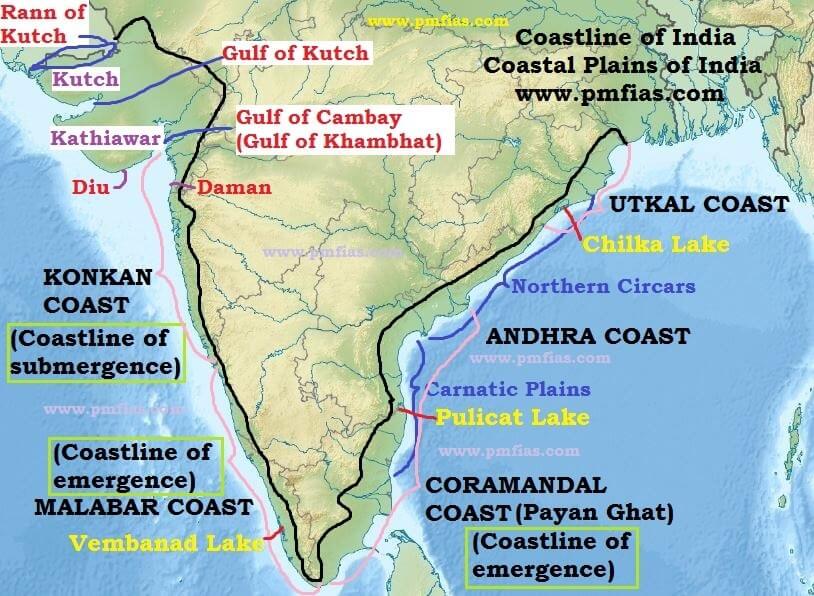
THE COASTAL INDIA
1. Introduction:
Coastal plains of India are the waved platforms and the raised beaches above the water
mark. These are mainly the emerged floors from the seas that are adjacent to the land.
The Peninsular India plateau is bordered by the narrow Coastal Plains. Following the
surfacing of these lowlands, the sea level fluctuations have brought some important
changes in the surface features of the sea shores. The Deccan plateau in India is also
surrounded by the coastal plains in the west and the east.
The Coastal plains that surround the Palghat town in the southern region of Kerala are
comparatively broad. In some places the width of the plains gets extended to about
96km. The off-shore bars are enclosed with lagoons running parallel to the coastal
plains in the south of Kerala. Also referred as Kayals, the lagoons receive water from
numerous rivers, to which these are linked through narrow openings. The coastal zone
located in the western part alongside the Arabian Sea is known in the south of Goa, as
Malabar, while in the north of Goa, it is called Konkan.
Further, there are numerous estuaries in the Indian Coastal Plains. Among these, the
major ones are Narmada River and Tapi River in the state of Gujarat. The plain is also
blessed with natural harbors such as Marmagao and Mumbai. In the south, the coastal
plains get combined with the salt water lakes also known as lagoons. Spits and sand
bars can be found at their mouths. The coast is popular for the serene backwaters. The
coastal plains alongside the Bay of Bengal are very extensive and also differ from the
plains in the western strip. Fast flowing, small rivers cut part the rocky coastal strip.
That what separates the coastal plains in India from the interior is a large land of mass
characterized by unique features. Though having limited vegetation, yet the coastal
plains in India significantly contributes to the geography of the country.
2. Coastal plains of India:

An Amazing Geologic Feature can be found both on the eastern as well the western
coasts of the country. Between the Eastern Ghats and the east coast of India are
located the East Coastal Plains extending from the Subamarekha river along the West
Bengal-Orissa border to Kanyakumari. A major part of the plains is formed as a result of the alluvial fillings of the littoral zone by the rivers Mahanadi, Godavari,
Krishna and Cauvery comprising some of the largest deltas.
Its western boundary is a discontinuous line of the Eastern Ghats, more precisely by
the contours of 75 m in Orissa, 100 m in Andhra Pradesh and 150 m in Tamil Nadu. In
contrast to the West Coastal Plains, these are extensive plains with an average width
of 120 km although it may be as wide as 200 km in the deltaic regions and as narrow
as 35 km in-between the deltas.
This plain is known as the Northern Circars between the Mahanadi and the Krishna
rivers and Carnatic between the Krishna and the Cauvery rivers.
Division of Eastern Coastal Plain: Depending upon physiographic variations, the
entire plain is divided into three regions.
• The Utkal plain
• The Andhra plain
• The Tamil Nadu Plain
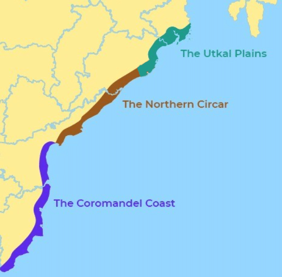
The Utkal Plains:
It is a coastal plains in eastern Orissa state, eastern India. Extending over about 16,000
square miles, the plains are bounded by the Lower Ganga Plain to the north, the Bay of
Bengal to the east, the Tamil Nadu Plains to the south, and the Eastern Ghats to the
west. The Utkal Plains are coastal lowlands consisting chiefly of Mahanadi delta
deposits and marine sediments, and they merge with the Eastern Ghats at an elevation
of about 250 feet. The plains have a nearly straight shoreline.
Paleogene and Neogene alluvium with patches of ancient Archean gneiss and
sandstone, the plains are widest in the deltaic regions. Sand dunes of decomposed
granites and zircon, created mainly by the action of wind at low tide, and lagoons are
found along the Bay of Bengal. Chilka, the largest lake in the region, is salty; Samang
and Sur are freshwater lakes. Littoral forests are found along the coast of the Cuttack
and Balasore areas, and tropical moist deciduous forests are found inland throughout
the regions near Puri and Cuttack. The Mahanadi, Brahmani, Baitarani, and
Subarnarekha rivers are often subject to heavy flooding; the combined outflow of
these rivers has formed the Mahanadi delta in the northern part of the plains. The
region has fertile red and black soils.
The Andhra Plain
It lies south of the Utkal Plain and extends upto Pulicat Lake, some 40 km north of
Chennai. This lake has been barred by a long sand spit known as Sriharikota Island, on
which is located the satellite launching station of the Indian Space Research
Organisation.
The lagoon is about 60 km long and about 16 km wide in its widest part. The most
significant feature of this plain is the delta formation by the rivers Godavari and
Krishna. In fact, the two deltas have merged with each other and formed a single
physiographic unit.
The combined delta has advanced by about 35 km towards the sea during the recent
years. This is clear from the present location of the Kolleru Lake which was once a
lagoon at the shore but now lies far inland. This part of the Andhra plain is quite wide.
Andhra plain has straight coast and badly lacks good harbours with the exception of
Vishakhapatnam and Machilipatnam.
The Tamil Nadu Plain
It stretches for 675 km from Pulicat lake to Kanniyakumari along the coast of Tamil
Nadu. Its average width is 100 km. The most important feature of this plain is the
Cauvery delta where the plain is 130 km wide. The fertile soil and large scale
irrigation facilities have made the Cauvery delta the granary of South India.
The expansive area of the eastern coastal plains that is the three broad divisions,
mentioned above can be further divided into 6 regions:
1. Mahanadi Delta in Orissa
2. Southern Andhra Pradesh Plain
3. Krishna Godavari deltas
4. Kanyakumari Coast
5. Coromandel or Madras Coast in Tamil Nadu
6. Sandy Coastal regions
3. The Western Coastal Plain

It is a narrow strip of land sandwiched between the Western Ghats and the Arabian
Sea, ranging from 50 to 100 km in width. It extends from Gujarat in the north and
extends through Maharashtra, Goa, Karnataka, and Kerala. Numerous rivers and
backwaters inundate the region. Major rivers flowing into the sea are the Tapi,
Narmada, Mandovi and Zuari.
Division of western coastal plain:
The Kachchh Peninsula:
The Kachchh Peninsula, located between latitude 23.13°-
24.68°N and longitude 68.10°-71.80°E, forms the western most part of India and
constitutes the Kachchh district of Gujarat State. Occupying an area of 45,612 sq km,
it has length and width extensions of 320 and 170 km, respectively through which
passes the Tropic of Cancer. The delta land of Sindh, also known in the olden times by
the name Sapta Sindhhu, or the seven distributaries of Indus River, borders it in the
west. Its 352 km long southern margin is demarcated by the Gulf of Kachchh, which
separates the peninsula from Saurashtra. Its northern margin makes the International
border with Pakistan and the eastern abuts Gujarat Mainland. The district has a
population of 1,526,321 people inhabiting 949 villages in ten Talukas, population
density of 33-persons/sq km, and a total of 466,239 housing units.
Txhe archaeological records reveal that the region was first inhabited by the people of
Harappan civilization during 3000-1500 BC.
The Kathiawar Peninsula:
It is also called Saurashtra Peninsula, peninsula in
southwestern Gujarat state, west-central India. It is bounded by the Little Rann of
Kachchh to the north, the Gulf of Khambhat to the east, the Arabian Sea to the
southwest, and the Gulf of Kachchh to the northwest. From the northeast an ancient
sandstone formation extends into the peninsula, which has an area of 23,000 square
miles. Most of the sandstone, however, is masked by lavas. The area flanking the Gulf
of Khambhat is largely alluvial.Much of the peninsula is less than 600 feet above sea level, but the Girnar Hills and the isolated Gir Range reach top elevations of 3,665 feet and 2,110 feet, respectively.
The natural vegetation of the dry, hot region is mainly thorn forest, but mangrove
stands are common in low-lying areas near the sea. Gir National Park in the south
contain the last wild Indian lions, and other wildlife abounds. Agriculture is the chief
occupation on the peninsula; the principal crops raised include wheat, millet, peanuts
and cotton. Bhavnagar is the principal port and city.
The Gujarat Plains:
The Konkan plain:
It is also called Aparanta, coastal plain of western India, lying
between the Arabian Sea and the Western Ghats. The plain stretches approximately
330 miles from the Daman Ganga River north of Mumbai to the Terekhol River
between Maharashtra and Goa states and Daman and Diu union territory in the south.
Between 28 and 47 miles in width, the Konkan includes the regions of Thane, Greater
Mumbai, Raigarh, and Ratnagiri.
The region is traversed by seasonal rivers that drain the heavy monsoonal rainfall from
the crest of the Sahyadri Hills. The generally uneven terrain is composed of eroded
remnant ranges of the Ghats that form low lateritic plateaus in the west and terminate
in a coastline of alternating bays and headlands. Only about one-third of the land is
cultivable, and the population lives mainly in the relatively fertile river valleys near
the coast and in the newly developed industrial belts around Mumbai, Thane, Khopali,
and Panvel. The barren hills are occupied by the pastoral Bhil, Kathkari, and Kokana
peoples. The main crops are rice, pulses, vegetables, fruits, and coconuts; fishing and
salt manufacture are also important.
The industrial complex of Greater Mumbai is the primary economic focus of the
region. Nearly all trade is carried on with Mumbai, and steady migration to the city
has left rural Konkan depleted of manpower and skilled workers. Iron and manganese
are mined and exported through the port of Reddi.
The ports of the Konkan were known to the ancient Greeks and Egyptians and to Arab
traders. The spice trade brought prosperity to the ancient Hindu kingdoms of the area.
The cave temples of Elephanta Island and Kanheri bear testimony to the prosperous
culture of this era. With the advent of the Portuguese and British, the port cities were
further developed and fortified but now have lost their former importance.
The Karnataka Coastal Plain: The Karnataka Coastal Plain from Goa to Mangalore
is about 225 km long. It is a narrow plain with an average width of 30-50 km, the
maximum being 70 km near Mangalore. The central part of this plain is crossed by
numerous spurs projecting from the Ghats.
These spurs approach so close to the coast that the breadth of the lowland is reduced to
5-7 km at 14°N latitude where the Ghat’s crest is only 13 km away from the sea.
Running like ridges, the spurs attain heights of more than 600 m. near the Ghats.
At some places the streams originating in the Western Ghats descend along steep
slopes and make waterfalls. The Sharavati while descending over such a steep slope
makes an impressive waterfall known as Jog Falls which is 271 m high. Marine
topography is quite marked on the coast.
The Kerala plain:
It is narrow strip of coastland, southwestern India, fronting the
Arabian Sea to the west and constituting almost all of Kerala state and most of the
Malabar Coast. Narrow in the north and wide in the south, the plains are about 330
miles long and from 12 to 60 miles wide, covering an area of about 11,000 square
miles. The plains are indented by numerous shallow lagoons, known as kayes, that are
formed by teris. The sandy beaches are covered with coconut palms. According to the
Purana, the region, also known as Parashurama Kshetram, was reclaimed from the sea
by the sage Parashurama. The Kerala Plains lie below 33 feet, with hills of the
Western Ghats, the Nilgiri, and the Southern Ghats to the east.
Many streams crisscross the plains and serve as inland waterways, constituting about
one-fifth of India’s total length of waterways. The Periyar River is the most important
river that crosses the plains.
4. Significance of the Coastal Plains:
Large parts of the coastal plains of India are covered by fertile soils on which different
crops are grown. Rice is the main crop of these areas. Coconut trees grow all along the
coast. The entire length of the coast is dotted with big and small ports which help in
carrying out trade.
About 98% of our international trade is carried through these ports. The sedimentary
rocks of these plains are said to contain large deposits of mineral oil. The sands of
Kerala coast have large quantity of monazite which is used for nuclear power. Fishing
is an important occupation of the people living in the coastal areas. Low lying areas of
Gujarat are famous for producing salt.
Conclusion:
SAYANTANI SINGH Msc, B.Ed
GEOGRAPHIA
If you want to join my telegram group
YOU TUBE CHANNEL LET'S LEARN GEOGRAPHY click here
NCERT CLASS_6 SHORT NOTE CLICK HERE
NCERT CLASS _6 SOLUTION CLICK HERE
ICSE class -ix click here
ICSE class -x click here
CLASS 6 WBBSE GEOGRAPHY CLICK HERE
জলবায়ুর শ্রেণীবিভাগপ্রশ্ন-উত্তর click here
REGIONAL THEORIES CLICK HERE
দ্বাদশ শ্রেণী ভূগোল CLICK HERE
CURRENT AFFAIRS CLICK HERE
NOTES OF HUMAN GEOGRAPHY AND AND POPULATION GEOGRAPHY click here
CONTINENTAL DRIFT THEORY BY FB TAYLOR CLICK HERE
CONTINENTAL DRIFT THEORY BY TAYLOR IN BENGALI CLICK HERE
CONTINENTAL DRIFT THEORY BY WEGNER CLICK HERE
CLIMATE OF INDIA CLICK HERE
ভূমিরূপ গঠন কারী প্রক্রিয়া ; উচ্চমাধ্যমিক ভূগোল click here
বহির্জাত প্রক্রিয়া ও তার ফলে সৃষ্ট ভূমিরূপ click here
মহিসঞ্চারন তত্ত্ব click here
Ugc net 2007 june paper 2 geography click here
Ugc net 2006 december paper 2 geography click here
UGC NET GEOGRAPHY 2007 DECEMBER CLICK HERE
UGC NET GEOGRAPHY 2008 JUNE CLICK HERE
WB CLASS 6 GEOGRAPHY CHAPTER 4 CLICK HERE
UGC NET GEOGRAPHY 2009 JUNE CLICK HERE
PLATE TECTONIC THEORY CLICK HERE
NCERT CLASS 7 GEOGRAPHY CLICK HERE
CORAL REEF IN BENGALI NOTE CLICK HERE
CORAL REEF CLICK HERE
HS GEOGRAPHY CLICK HERE
Thank you for visiting this page.we provide geography related study materials on daily basis..


0 Comments