
GEOGRAPHY IMPORTANT QUESTIONS SERIES 13
.png)
91. The first Biosphere Reserve of India established in 1986 is :
(1) Manas
(2) Nanda Devi
(3) Nokrek
(4) Nilgiri


92. Which is not an example of a 'Garrison town' in India ?
(1) Ambala
(2) Jalandhar
(3) Mhow
(4) Satna
EXPLAINATION:
👉Garrison towns are fortified settlements, with soldiers. The main function of the garrison towns is to cater to the needs of defence and people employed in defence services of the nation. These are specially designed for the purpose of military, navy or airforce activities.
👉Garrison towns are the towns whose formation is a result of the setting up of a military base. They are also referred to as cantonment towns. Ambala, Mhow, etc can be referred to as garrison towns. The main function of the garrison towns is to cater to the needs of defence and people employed in defence services of the nation. These are specially designed for the purpose of military, navy or airforce activities.
93. Which of the following is not a mathematical method for representation of relief ?
(1) Spot height
(2) Bench mark
(3) Hachures
(4) Form lines
94. What is Metadata ?
(1) It is oceanic data.
(2) It is survey data.
(3) It is meterological data.
(4) It is data about data.
EXPLAINATION: Metadata is data about data. It's information that describes, explains, locates, or makes it easier to retrieve, use, or manage other data. Essentially, it's a "data passport" that provides context and details about the actual content.
Examples:
In a file:
The file name, size, type, creation date, and last modified date are all metadata.
On a webpage:
Meta tags in the HTML code (like description and keywords) provide metadata for search engines.
In a library:
Card catalogs with author, title, and subject information for books are metadata.
For images:
Information like camera settings, date taken, and location are metadata.
Why is it important?
- Findability: Metadata makes it easier to search for and retrieve specific data.
- Usability: It helps understand how to use the data correctly.
- Management: Metadata facilitates the organization, storage, and preservation of data.
- Interoperability: Metadata allows different systems to understand and use the same data.
95. What is the conversion of statement scale of "1 inch represents 8 miles" into RF ?
(1) 1 : 570,240
(2) 1 : 380,160
(3) 1 : 443,520
(4) 1 : 506,880
EXPLAINATION:
The fraction's numerator is the number above the line.
For example In a fraction of 1 : 50000,1 is the numerator
As we know that,1 mile = 63360 inch
1 -inch scale represents 8miles
8 mile = 63360 ×8 =506,880
Therefore the R:F is 1 : 506,880
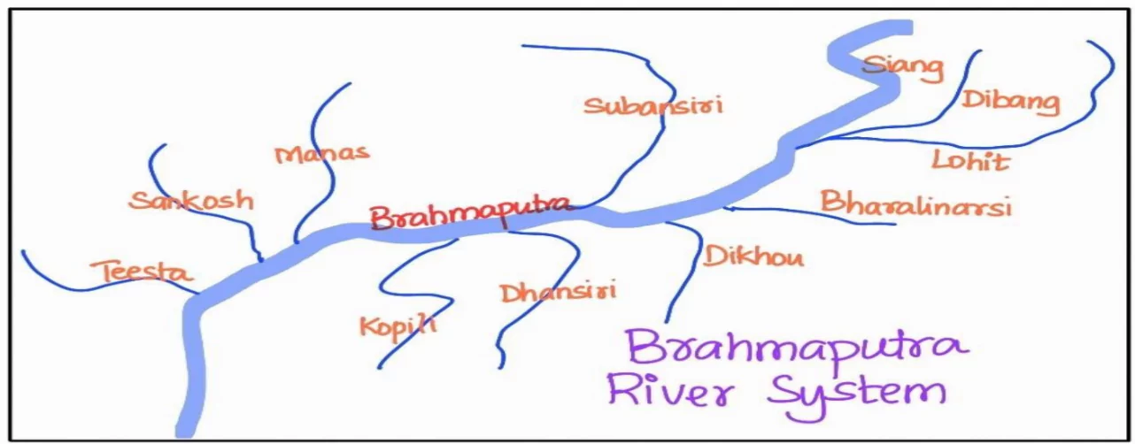
96. Which of the following is not a right hand tributary of River Brahmaputra ?
(1) Tista
(2) Manas
(3) Kalong
(4) Subanseri

97. Distances measured along erratic paths of coastlines, rivers and streams is done by an instrument called :
(1) Planimeter
(2) Opisometer
(3) Pluviometer
(4) Hydrometer
- EXPLAINATION: A planimeter measures area,
- an opisometer measures lengths of curved lines,
- a pluviometer measures rainfall, and
- a hydrometer measures the specific gravity of liquids.
98. Which of the following oil producing regions is not situated in Assam ?
(1) Digboi
(2) Shivsagar
(3) Naharkatiya
(4) Aliyabet
EXPLAINATION: All the oil and gas fields, discovered till date in the Upper Assam shelf, are situated mostly on the southeastern slope of the Brahmaputra arch, and almost all the major oil fields like Nahorkatiya, Lakwa, Lakhmani, Geleki, Dikom Kathaloni etc. lie in a belt bordering the Naga thrust. In the Dhansiri valley also, oil fields like the Borholla and Khoraghat and Nambar lie in the same belt. In the Naga Schuppen belt, oil accumulations in the Lakshmijan and the Champang oil fields occur in that zone of the shelf which is overridden by the Naga thrust. In the Digboi and Kharsang oil fields, oil occurs in Tipam Sandstone and Girujan Clay formations, respectively, overlying the Naga thrust.
99. Consider the following statements :
(a) The distance between two latitudes is approximately 111 km.
(b) There are 180 parallels including equator.
(c) All meridians converge at poles.
Choose the correct answer :
(1) Only (b) is correct.
(2) (a) and (c) are correct.
(3) (a) and (b) are correct.
(4) (a), (b) and (c) are correct.
EXPLAINTION: There are a total of 181 latitudes drawn at 1-degree intervals on the Earth's surface, including the equator and the poles. This includes 90 degrees of latitude in the Northern Hemisphere, 90 degrees in the Southern Hemisphere, and the equator at 0 degrees.
100. What is 95° Fahrenheit in Celsius ?
(1) 35°
(2) 95°
(3) 63°
(4) 36°
101. In which of the following two or more than two contour lines meet at a point ?
(1) Conical hill
(2) Ridge
(3) Water fall
(4) Gentle slope


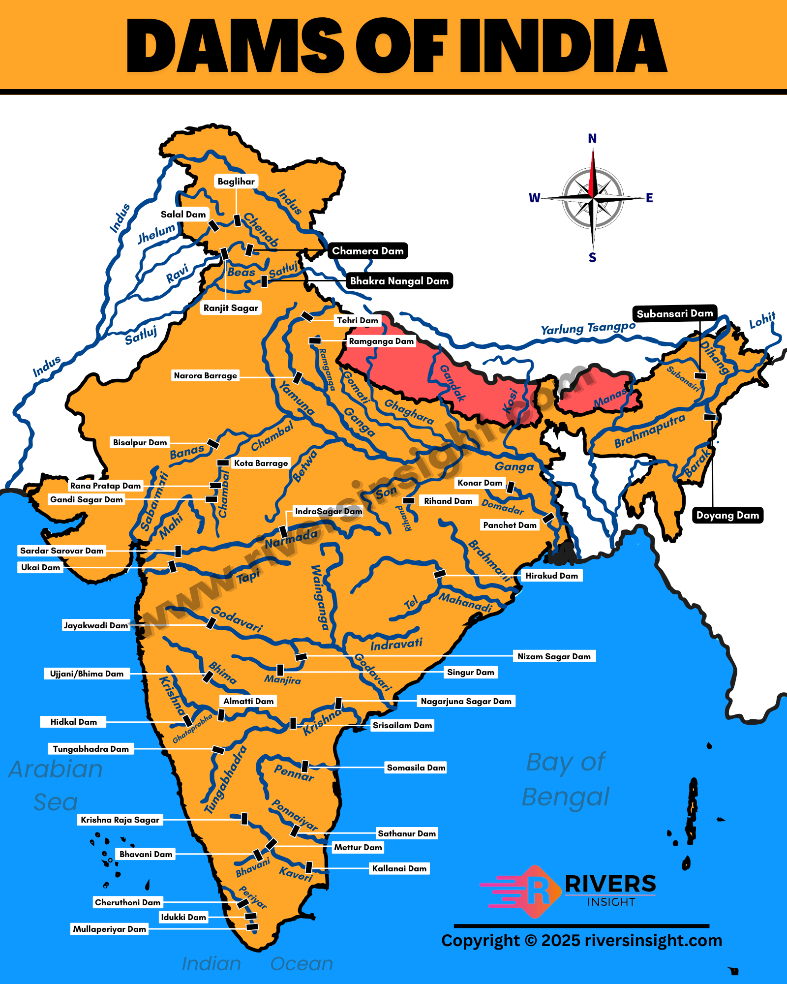
102. Which is the incorrect pair ?
(1) Matatila Dam – River Betwa
(2) Shivasamudram Dam – River Krishna
(3) Bhakranangal Dam – River Sutlej
(4) Pong Dam – River Beas
103. Consider the following statements regarding 'Regur Soils' of India :
(a) They are generally deep & clayey.
(b) During dry season these soils develop wide cracks.
(c) They develop a reddish colour due to iron presence.
Choose the correct option :
(1) Only (a)
(2) (a), (b) and (c)
(3) (a) and (c)
(4) (a) and (b)
EXPLAINATION: Characteristics:
Color:
Black or very dark in color, often with a chroma of ≤3 moist, a value of ≤3 moist and ≤5 dry (by Munsell colors).
Rich in humus:
Contains a high percentage of organic matter, contributing to its fertility.
Mineral content:
High in iron, lime, magnesium, and also contains potassium.
Clay content:
Contains clay minerals like montmorillonite, which gives it a high capacity to retain moisture.
High compressibility and low bearing capacity:
These properties can affect construction and engineering projects in areas with black soil
104. Choose the correct pair :
(1) Mango Shower – Coastal Tamil Nadu
(2) Bardoli Chheerha – Tripura
(3) Norwesters – West Bengal,Assam
(4) Blossom Showers – Andhra Pradesh
105. Loxodrome is :
(1) a straight line joining two points on a projection giving a constant bearing.
(2) a 180° longitude drawn on a Lambert's projection.
(3) a graticule drawn parallel to equator.
(4) a curved line joining two points on a projection giving a constant bearing.
106. 'The Neeru-Meeru (Water and You) Programme' for constructing water harvesting structures is launched in :
(1) Gujarat-Maharashtra
(2) Andhra Pradesh
(3) Rajasthan
(4) Punjab-Haryana
107. Which among the following is a large scale map ?
(1) Topographical map
(2) Wall map
(3) Cadastral map
(4) Atlas map
EXPLAINATION: Cadastral Map : A large-scale map drawn at a scale of 1 : 500 to 1 : 4000 to show property boundaries, designating each parcel of land with a number.The term ‘cadastral’ is derived from the French word ‘cadastre’ meaning ‘register of territorial property’.
(1) Meteorological drought
(2) Agricultural drought
(3) Ecological drought
(4) Hydrological drought
109. Choose the incorrect pair :
Mineral Major Producer
(1) Iron Ore – Sundargarh, Mayurbhanj
(2) Manganese – Shimoga, Chitradurg
(3) Bauxite – Belgaum, Chikmanglur
(4) Copper – Balaghat, Singhbhum
110. According to G. T. Trewartha's scheme of climate classification, 'Caw' type of climate is found in which parts of India ?
(2) Western Desert
(3) Deccan Plateau
(4) Coastal Plains

111. 'Bugyals' are :
(1) Nomadic groups of Kashmir Himalayas
(2) Summer Grasslands
(3) Glacial lakes of Uttarakhand
(4) Meanders formed by river Jhelum
explaination: The nomadic groups of the Kashmir Himalayas include the Gujjar Bakarwals and the Changpa.
112. The local names – panna, para, palli, nagla – refer to which type of
settlements in India ?
(1) Semi-clustered
(2) Hamleted
(3) Dispersed
(4) Clustered
explaination :Clustered (or Nucleated):
(1) 67.15% – 35.31%
(2) 68.58% – 31.51%
(3) 68.85% – 31.15%
(4) 65.17% – 35.11%
114. Which of the following statement regarding, prismatic compass survey is correct ?
(1) the magnetic needle moves with the wooden box.
(2) sight vane does not move with the box.
(3) the magnetic needle and graduated circle do not move with the box.
(4) The graduated circle is fixed and the magnetic needle always remain in N-S direction.
115. Consider the following statements :
(a) Sun synchronous satellites are useful for Earth Resource applications.
(b) Geostationary satellites are useful for Telecommunications and Weather monitoring.
Choose the correct options :
(1) Both (a) and (b) are wrong.
(2) Only (a) is correct.
(3) Only (b) is correct.
(4) Both (a) and (b) are correct.
116. Match List – I with List – II and select the correct answer from the codes given
below :
List – I List – II
(Headquarters)
(Railway Zones)
(a) Central (i) Maligaon (Guwahati)
(b) East Central (ii) Allahabad
(c) North Central (iii) Hajipur
(d) North East Frontier(iv) Mumbai
Codes
(a) (b) (c) (d)
(1) (iv) (iii) (i) (ii)
(2) (iii) (iv) (i) (ii)
(3) (i) (ii) (iii) (iv)
(4) (iv) (iii) (ii) (i)
117. With reference to International Date Line, consider the following statements :
(a) A person crossing it from east to west gains a day.
(b) It is an imaginary straight line drawn at 180° meridian.
Choose the correct answer :
(1) Only (a)
(2) Only (b)
(3) Both (a) & (b)
(4) Neither (a) nor (b)
118. The length of Gunter's chain, used for chain and tape surveying, is :
(1) 86 Feet
(2) 68 Feet
(3) 36 Feet
(4) 66 Feet
119. If the source of light is on opposite end of diameter, the resultant projection will be :
(1) Gnomonic
(2) Stereographic
(3) Orthomorphic
(4) Orthographic
120. Compute the scale of an aerial photograph when the flying height of an aircraft is 7500 m and the focal length of the camera is 15 cm :
(1) 1 : 15,000
(2) 1 : 50,000
(3) 1 : 25,000
(4) 1 : 30,000
The flying height of the aircraft is 7500 m. The focal length of the camera is \15 cm.
121. The transfer of heat through horizontal movement of air is called :
(1) Convection
(2) Diffusion
(3) Albedo
(4) Advection
122. In ocean water, the layer characterized by rapid decrease in temperature with increasing depth is known as :
(1) Pycnocline
(2) Thermocline
(3) Isohaline
(4) Drift
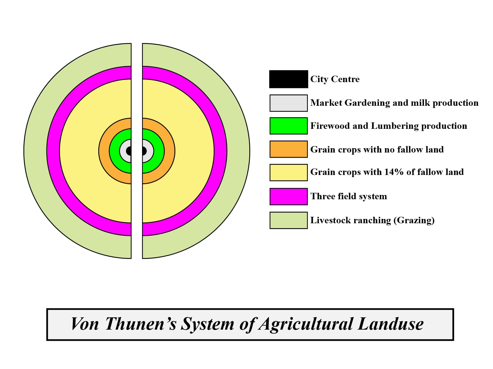
123. Consider the following statements regarding 'Von Thunen's Model' :
(a) Locational rent shows a distance – decay relationship.
(b) Farmers are economic men, aiming at profit maximization.
(c) There are numerous market centres around the Isolate State.
Choose the correct answer :
(1) only (a)
(2) (a) and (c)
(3) (a), (b) and (c)
(4) (a) and (b)
124. Which is the incorrect pair ?
(1) Gaseous hypothesis – Kant
(2) Planetesimal hypothesis – Chamberlin & Moulton
(3) Nebular hypothesis – Laplace
(4) Meteor hypothesis – Buffon
125. The three principles/restrictions for industrial location developed by Rawstron are :
(1) Physical, Economic and Technical
(2) Physical, Economic and Social
(3) Physical, Economic and Political
(4) Physical, Economic and Human
126. The new trend in quarternary services, KPO stands for :
(1) Knowledge Professional Outsourcing
(2) Knowledge Professional Output
(3) Knowledge Process Output
(4) Knowledge Process Outsourcing
127. Consider the following statements regarding 'Demographic Transition Theory' :
(a) Decline in mortality comes before decline in fertility.
(b) Fertility eventually declines to match mortality.
(c) The slow growth of population in first stage is a result of high fertility and high mortality.
Choose the correct answer :
(1) (a), (b) and (c)
(2) (a) and (c)
(3) (b) and (c)
(4) only (c)
128. Choose the correct option :
(1) The longest span on the geological scale is epoch.
(2) The longest span on the geological scale is era.
(3) Periods are divided into eras.
(4) Epochs are further divided into periods.
129. As per the latest Human Development Index Report 2018, out of 189 countries, India has been ranked at :
(1) 129
(2) 130
(3) 131
(4) 132
130. Soo canal connects :
(1) Lake Superior – Lake Michigan
(2) Lake Superior – Lake Huron
(3) Lake Huron – Lake Erie
(4) Lake Superior – Lake Ontario
131. 'Pastoral Nomadism' is associated with :
(a) Atlantic shores of North Africa, Arabian Peninsula to Central China
(b) Tundra Region
(c) South East Asia
Choose the correct answer :
(1) only (b)
(2) (a) and (c)
(3) (a), (b) and (c)
(4) (a) and (b)
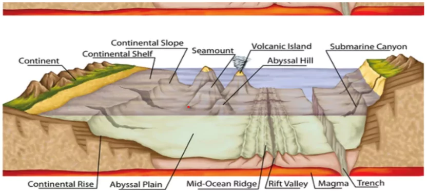
132. Which of the following ocean bottom relief feature is important from the ecological point of view contributing in the formation of ideal places for mangrove forests in India ?
(1) Continental shelf
(2) Continental rise
(3) Continental slope
(4) Continental plain
133. Which is the incorrect pair ?
(1) Inland Port – Memphis
(2) Out Port – Piracus
(3) Entrepot Port – Copenhagen
(4) Port on call – Duisburg
134. Based on principal organisms the calcareous oozes are further divided into :
(1) Red clay and Globigerina ooze
(2) Diatom and Radiolarian ooze
(3) Pteropod and Globigerina ooze
135. Who defined human geography as 'a synthetic study of relationships between human societies and earth's surface' ?
(1) C. Ritter
(2) F. Ratzel
(3) E. C. Semple
(4) Vidal de La Blache
136. Which is the incorrect pair ?
(Koeppen Climatic Classifications)
(1) Af – Tropical wet
(2) Bwh – Sub-tropical steppe
(3) Df – Cold humid continental
(4) Aw – Tropical wet and dry
137. Which of the following station is not on Canadian-Pacific Railway Route ?
(1) Vancouver
(2) Alberta
(3) Halifax
(4) Montreal
138. Consider the following statements :
(a) Plates are irregular-shaped slabs of solid rocks.
(b) Plates move horizontally over asthenosphere.
(c) Thickness of plates varies between 5-200 kms.
Choose the correct answer :
(1) Only (a)
(2) (a) and (b)
(3) (a), (b) and (c)
(4) Only (c)
139. Who considered the principle of terrestrial unity as the corner stone of human geography and gave the concept of 'Genre-de-Vie' (life style) ?
(1) Otto Schluter
(2) Jean Brunhes
(3) Albert Demangeon
(4) Vidal de La Blache
140. Which of the following country does not lie in the top 10 most populated countries of the world (as per year 2011) ?
(1) Brazil
(2) Indonesia
(3) Germany
(4) Nigeria
141. 'Man is a product of the earth's surface' was stated by :
(1) C. O. Sauer
(2) E. C. Semple
(3) F. Ratzel
(4) E. Huntington
142. Match List – I with List – II and select the correct answer using the codesgiven below :
List – I List – II
(a) Cyclone ( i) Atlantic Ocean
(b) Hurricane (ii) Western Australia
(c) Typhoon (iii) Indian Ocean
(d) Willy-Willy (iv) Western Pacific and South China Sea
Code :
(a) (b) (c) (d)
(1) (iii) (i) (iv) (ii)
(2) (i) (ii) (iii) (iv)
(3) (iv) (iii) (ii) (i)
(4) (ii) (iii) (i) (iv)
143. Which of the following industrial region of Japan is known as 'Detriot of Japan' ?
(1) Osaka – Kobe
(2) Tokyo – Yokahama
(3) Nagoya
(4) Kyushu
144. Which of the following is not an igneous rock ?
(1) Geyserite
(2) Pegmatite
(3) Tuff
(4) Gabbro
145. Arrange the salts found in oceans in descending order with respect to their abundance :
(1) Sodium chloride, Potassium sulphate, Magnesium Sulphate
(2) Sodium chloride, Magnesium chloride, Magnesium sulphate
(3) Potassium chloride, Sodium chloride, Calcium sulphate,
(4) Sodium chloride, Calcium chloride, Magnesium sulphate
146. Which is the incorrect pair ?
Shifting Cultivation Country
(1) Caingin – Philippines
(2) Taungya – Myanmar
(3) Masole – Brazil
(4) Chena – Sri Lanka
147. The central theme of Pratt's concept of Isostasy was :
(1) Uniform density with varying thickness
(2) Law of floatation
(3) Uniform depth with varying density
(4) Root formation
148. Which are the Jovian planets ?
(1) Mercury, Venus, Earth, Mars
(2) Earth, Mars, Jupiter, Saturn
(3) Jupiter, Saturn, Uranus, Neptune
(4) Venus, Earth, Mars, Jupiter
149. 'The Mobility Transition Model' for migration was given by :
(1) Ravenstein
(2) Zelinsky
(3) Lee
(4) Wolpert
150. Match List – I with List – II and select the correct answer using the codes given below :
List – I List – II
(a) Llanos (i) New Zealand
(b) Canterbury (ii) Hungary
(c) Pustaz (iii) Venezuela
(d) Velds (iv) South Africa
Code :
(a) (b) (c) (d)
(1) (iii) (ii) (i) (iv)
(2) (iii) (ii) (iv) (i)
(3) (iv) (i) (ii) (iii)
(4) (iii) (i) (ii) (iv)


.png&description= GEOGRAPHY IMPORTANT QUESTIONS SERIES 13)
0 Comments