
MOUNTAIN AND ITS TYPES OF MOUNTAIN
Landform is a natural feature of the earth’s surface. The surface of the earth varies from one place to another. The main landforms are; mountains, plateau and plains. There are two processes which lead to formation of different landforms. These processes are; internal process and external process.
MOUNTAIN AND ITS TYPES OF MOUNTAIN
Mountain, landform that rises prominently above its surroundings, generally exhibiting steep slopes, a relatively confined summit area, and considerable local relief. On the other hand , Mountains are formed by slow but gigantic movements of the earth's crust (the outer layer of the Earth).A mountain belt is many tens to hundreds of kilometres wide and hundreds to thousands of kilometres long.
Characteristics of Mountains
- A mountain is the natural elevation of the earth’s surface.
- A mountain may be narrow at top and broad at the base.
- The elevation of mountain is considerably more than that of surrounding area.
- Temperature reduces with increase in altitude.
- Due to this, very high mountains are usually covered with snow.
- Mountain Range: When mountains are arranged in a line, then it is called a mountain range. Some of the mountain systems contain ranges spread over hundreds of kilometers.
- Mountains generally are understood to be larger than hills, but the term has no standardized geological meaning.
- Very rarely do mountains occur individually. In most cases, they are found in elongated ranges or chains. When an array of such ranges is linked together, it constitutes a mountain belt.
How are mountains formed?
Mountains are formed by slow but gigantic movements of the earth's crust (the outer layer of the Earth).The Earth's crust is made up of 6 huge slabs called plates, which fit together like a jigsaw puzzle. When two slabs of the earth's crust smash into each other the land can be pushed upwards, forming mountains. Many of the greatest mountain ranges of the world have formed because of enormous collisions between continents.Mountains and mountain belts exist because tectonic processes have created and maintained high elevations in the face of erosion, which works to destroy them. The topography of a mountain belt depends not only on the processes that create the elevated terrain but also on the forces that support this terrain and on the types of processes (erosional or tectonic) that destroy it.
Types of Mountains
There are 4 types of mountains:
1. fold mountains,
2. block mountains
3.volcanic mountains,
4.Dome Mountains
5.Plateau Mountains
Fold Mountains

- Fold mountains are the most common type of mountain. The world’s largest mountain ranges are fold mountains. These ranges were formed over millions of years.
- Fold mountains are formed when two plates collide head on, and their edges crumbled, much the same way as a piece of paper folds when pushed together.
- Where an area of sea separates two plates, sediments settle on the sea floor in depressions called geosynclines. These sediments gradually become compressed into sedimentary rock.
- When the two plates move towards each other again, the layers of sedimentary rock on the sea floor become crumpled and folded.
- Eventually the sedimentary rock appears above sea level as a range of fold mountains.
- Where the rocks are folded upwards, they are called anticlines. Where the rocks are folded downwards, they are called synclines. Severely folded and faulted rocks are called nappes.
- Examples of fold mountains include:
- Himalayan Mountains in Asia
- the Alps in Europe
- the Andes in South America
- the Rockies in North America
- the Urals in Russia
Block Mountains
When large areas are broken and displaced vertically, Block Mountains are formed. In this case, the uplifted blocks are called horsts. On the other hand, the lowered blocks are called graben.
Examples of fault-block mountains include:
the Sierra Nevada mountains in North America
the Harz Mountains in Germany

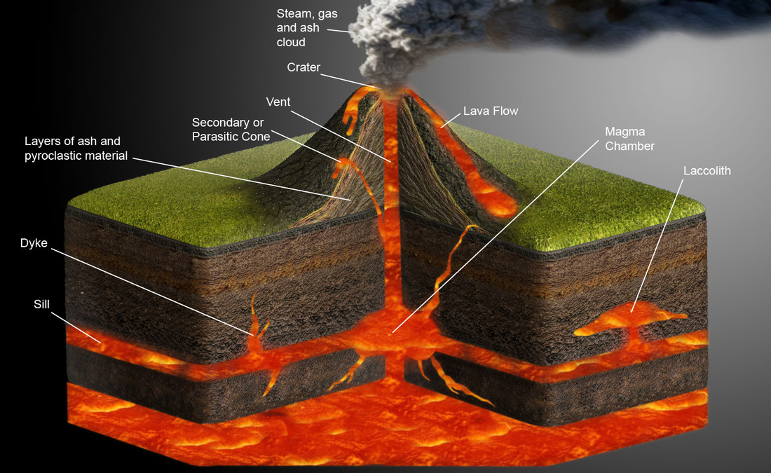
Volcanic Mountains
When tectonic plates move about, volcanoes are formed, and when volcanoes erupt, mountains are formed in turn.A shield volcano has a gently sloping cone due to the low viscosity of the emitted material, primarily basalt. Mauna Loa is the classic example, with a slope of 4°-6°.
The composite volcano or stratovolcano has a more steeply rising cone (33°-40°), due to the higher viscosity of the emitted material, and eruptions are more violent and less frequent than for shield volcanoes.
Most volcanic mountains occur in a band surrounding the Pacific Ocean. Collectively they are known as the Pacific Ring of Fire. The famous volcanic mountains are stratovolcanoes or shield volcanoes. Examples of a stratovolcano is Vesuvius and Mount Fuji, while a shield volcano is Mauna Loa on Hawaii.
Dome Mountains

Dome mountains are the result of a great amount of melted rock (magma) pushing its way up under the earth crust. Without actually erupting onto the surface, the magma pushes up overlaying rock layers. At some point, the magma cools and forms hardened rock. The uplifted area created by rising magma is called a dome because of looking like the top half of a sphere (ball). The rock layers over the hardened magma are warped upward to form the dome. But the rock layers of the surrounding area remain flat.
Plateau Mountains

Plateau mountains are actually formed by the Earth’s internal activity; instead, they’re revealed by erosion. They’re created when running water carves deep channels into a region, creating mountains. Over billions of years, the rivers can cut deep into a plateau and make tall mountains. Plateau mountains are usually found near folded mountains. Plateau mountains are often found near folded mountains. As years pass, streams and rivers erode valleys through the plateau, leaving mountains standing between the valleys.
The mountains in New Zealand are examples of plateau mountains
READ MORE
one day one concept CLICK HERE
GENERAL KNOWLEDGE PART 1 CLICK HERE
GEOLOGICAL TIME SCALE IN ENGLISH CLICK HERE
GEOLOGICAL TIME SCALE IN BENGALI CLICK HERE .
পৃথিবীর অন্দরমহলের বর্ননা click here
interior structure of the earth click here
KANT GASEOUS HYPOTHESIS CLICK HERE
কান্টের গ্যাসীয় মতবাদ CLICK HERE
Free note for REMOTE SENSING AND GIS CLICK HERE
Regional planning in india click here
NCERT CLASS_6 SHORT NOTE CLICK HERE
NCERT CLASS _6 SOLUTION CLICK HERE
ICSE class -ix click here
ICSE class -x click here
CLASS 6 WBBSE GEOGRAPHY CLICK HERE
জলবায়ুর শ্রেণীবিভাগপ্রশ্ন-উত্তর click here
REGIONAL THEORIES CLICK HERE
দ্বাদশ শ্রেণী ভূগোল CLICK HERE
CURRENT AFFAIRS CLICK HERE
NOTES OF HUMAN GEOGRAPHY AND AND POPULATION GEOGRAPHY click here
CONTINENTAL DRIFT THEORY BY FB TAYLOR CLICK HERE
CONTINENTAL DRIFT THEORY BY TAYLOR IN BENGALI CLICK HERE
CONTINENTAL DRIFT THEORY BY WEGNER CLICK HERE
CLIMATE OF INDIA CLICK HERE
ভূমিরূপ গঠন কারী প্রক্রিয়া ; উচ্চমাধ্যমিক ভূগোল click here
বহির্জাত প্রক্রিয়া ও তার ফলে সৃষ্ট ভূমিরূপ click here
মহিসঞ্চারন তত্ত্ব click here
Ugc net 2007 june paper 2 geography click here
Ugc net 2006 december paper 2 geography click here
UGC NET GEOGRAPHY 2007 DECEMBER CLICK HERE
UGC NET GEOGRAPHY 2008 JUNE CLICK HERE
WB CLASS 6 GEOGRAPHY CHAPTER 4 CLICK HERE
UGC NET GEOGRAPHY 2009 JUNE CLICK HERE
PLATE TECTONIC THEORY CLICK HERE
NCERT CLASS 7 GEOGRAPHY CLICK HERE
CORAL REEF IN BENGALI NOTE CLICK HERE
CORAL REEF CLICK HERE
HS GEOGRAPHY CLICK HERE
GEOGRAOHICAL TERM click here
NTA NET GEOGRAPHY PYQS- MODELS AND THEORIES, 2020-2006, PART-1 CLICK HERE
NTA NET GEOGRAPHY PYQS- MODELS AND THEORIES, 2020-2006, PART-2 CLICK HERE
NTA NET GEOGRAPHY PYQS- MODELS AND THEORIES, 2020-2006, PART-3 CLICK HERE
NTA NET GEOGRAPHY IMPORTANT ONE LINER , 2020-2006, PART-1 CLICK HERE
NTA NET GEOGRAPHY CLIMATOLOGY PYQS 2020-2006 PART 1 CLICK HERE
NTA NET GEOGRAPHY GEOMORPHOLOGY 2020-2006 PART 1CLICK HER E


0 Comments