GEOGRAPHY: GUJARAT// PHYSICAL PART 01
INTRODUCTION:
India is a land of diversities in the planet earth. Geography of India is an essential
subject to be studied by every citizen of the country. As a nation, India occupies a significant
position in the world. It is a country known for its unique culture, history, heritage, natural
resources and human capital. India is a union of states. For administrative reasons, the
country is divided into 28 states and 8 union territories. Each part of India is unique in its
geography, culture, language and socio-economic conditions.
Gujarat is one of the prominent states in India. The main objective of learning this lesson
is to know about its geographic setting, people, governance and contributions in the country.
It is necessary to understand:
a) The physiographic setting
b) The climate, rainfall and land cover
c) The administrative divisions and population
d) Economic resources and contributors
e) Culture, tourism and unique features of the state as a whole.
Gujarat state is known for its role in the economic history of India. It is the home for
all Gujarati-speaking people of India.
LOCATION
Gujarat is located in the western India. Geographically, Gujarat lies in between 20° 6'
N to 24° 42' N north latitudes and 68° 10'E to 74° 28'E east longitudes.
It covers an area of 196030 Sq Km. with a coastline of 1600 Km. The state is
bordered by Rajasthan to the North, Maharashtra to the South, Madhya Pradesh to the east
and the Arabian Sea as well as the Pakistani province of Sindh on the West. It is the State
known for the Indus Valley civilization.
ESTABLISHMENT
Gujarat became an independent state on 1st May 1960. The first capital of Gujarat
was Ahmedabad and since 1970, Gandhinagar is named as its capital. The State has the
fastest growing economy in India.
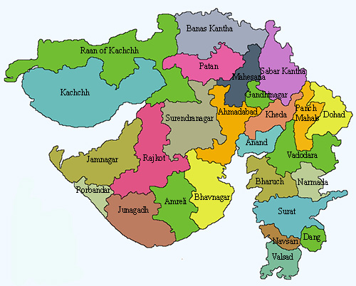
Gandhinagar is the capital city. The other major cities are Ahmedabad, Vadodara,
Surat, Rajkot, Bhavnagar and Jamnagar.
Gujarat is the 7thlargest state by area in India. Gujarat is the 10th largest state in India
by population.
LANGUAGE SPOKEN BY PEOPLE
Gujarati is the official language of the state, which is spoken by 84.5 % of the people.
Gujarati is an Indo-Aryan Language evolved from Sanskrit. People from Kutch region speak
in Kutchi language. Other native languages spoken in low proportions are Bhili and Gamit.
About 5% of the population speak native tribal languages, 4.7% Hindi, 2% Sindhi, 1.5%
Marathi and 1% Urdu language.
PHYSIOGRAPHY AND NATURAL REGIONS
The state of Gujarat occupies the northern extremity of the western India. Based on
the physiographic characteristics, Gujarat state has been divided into three major
morphological regions.
They are:
a) The peninsula, traditionally known as Saurashtra. It is essentially a hilly tract
sprinkled with low mountains.
b) Kutch on the north-east part of Gujarat. It is a barren and rocky area containing
the famous Rann (desert) of Kutch, the big Rann in the north and the little Rann in
the east.
c) The mainland extending from the Rann of Kutch and the Aravalli Hills to the river
Damanganga, is on the whole a level plain of alluvial soil.
Mainland Regions – The Mainland of Gujarat consists of North Gujarat, Central Gujarat and
the Plains of South Gujarat which are spread in the valley regions of Narmada, Mahi and
Tapti rivers. In the north-eastern region of mainland Gujarat, there are the Aravalli mountain
regions, with heights of about 150 to 319 meters. In the eastern side of mainland Gujarat,
there are the Saputara mountain ranges, which have heights between 150 and 243 meters.
These regions separate Gujarat from the western Khandesh of Maharashtra and divides
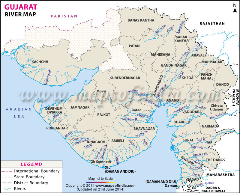
Narmada and Tapti into two parts. Tapti, Mahi, Sabarmati and Narmada rivers flow through
the alluvial plains of these mountain ranges.
Peninsula Regions: The Peninsular Gujarat is divided into three parts such as High Lands,
Interior Plains and Coastal Saurashtra Regions. In the central high lands, rivers Machhu,
Shetrunji and Bhadar flow towards the Arabian Sea through the Gulf of Khambhat. In the
Northern part of Saurashtra, there are muddy plains and large areas of saline lands.
NATURAL REGIONS:
Gujarat is a state endowed with many natural regions. The National parks include Vansda
National Park, Blackbuck National Park, Velavadar and Marine National Park, Gulf of Kutch.
Wildlife sanctuaries include: Wild Ass Wildlife Sanctuary, Nal Sarovar Bird Sanctuary,
Porbandar Bird Sanctuary, Kutch Desert Wildlife Sanctuary, Kutch Bustard Sanctuary, Narayan
Sarovar Sanctuary, Jessore Sloth Bear Sanctuary, Anjal, Balaram-Ambaji, Barda, Jambughoda,
Khavda, Paniya, Purna, Rampura, Ratanmahal, and Surpaneshwar.
The major mountain-ranges of India, like Aravalli, Sahyadri, Vindhya and Satpura are all in
Gujarat. Apart from this, Gir hills, Barda, Jessore, Chotila etc. are situated in different parts
of the State. Girnar is the tallest hill of Gujarat. Saputara is the only hill-station of the state.
Narmada is the biggest river of Gujarat followed by Tapti, although Sabarmati covers the
longest area in the state. Sardar Sarovar Project is built on Narmada River.
Narmada is one of
the major rivers of peninsular India with a length of around 1312 Km. It is one of the three
rivers of peninsular India that runs from east to west. There are altogether about 31 rivers
draining through the lands of Gujarat.
There are some notable lakes like Kankaria Lake, Gaurishankar Lake and Gogha existing in
Gujarat.
GEOLOGY:
The geology of Gujarat is very complex. In Kutch, the high ground is overlain by hard
volcanic rock (Basalt) or deep layers of weathered Sandstones, Shales, marls and limestone.
Coastal and lowland areas are water logged. In the Saurastra region of Gujarat, the geology is
mainly comprising of Basalt with few limestone outcrops west of Jamnagar. A deep layer of
recent alluvium occur along river courses.
CLIMATE:
The state’s annual temperature varies very widely from 6 to 45oC. It has tropical
climates, namely sub humid, arid, and semi arid spread over different regions of the state.
North Gujarat region comprising of Kutch, part of Banaskantha, Mehsana and North Western
part of Saurashtra, all have arid climate, while the South Gujarat enjoys sub humid climate
and in the rest of the state, the semi arid climate prevails.
RAINFALL:
Gujarat state receives an average annual rainfall of 828 mm in 35 rainy days. The
coefficient of variation of rainfall is 50%. There is a large spatial and temporal variation in
rainfall of the state. Kutch district and western parts of Banaskantha and Patan districts and
parts of Jamnagar, Rajkot and Surendranagar districts are regions which receive, less than
500 mm rainfall. The high rainfall of (> 1000 mm), is received in Dang, Valsad, Navsari and
Surat districts. The rest of the state receives a rainfall between 500-1000 mm and generally
fall under semi-arid climate.
WATER RESOURCES:
Gujarat has a good amount of water resources. Gir forms the catchments of seven perennial
rivers viz. Hiran, Saraswati, Datardi, Shingoda, Machhundri, Ghodavadi and Raval. During
peak summer, surface water for wild animals is available at about 300 water points. In order
to tap water resources, 4 dams have been constructed along Hiran, Machhundri, Raval and
Shingoda respectively. The total catchments area of these 4 reservoirs is 820 Sq Km.
The State Fisheries Department of Gujarat has listed 50 reservoirs suitable for fisheries,
covering an area of 2,42,205 ha. This is in addition to 561 small irrigation tanks, which are
actually reservoirs, with a water spread of 44,025 ha. Thus, the total area under reservoirs in
the State is 2,86,230 ha.
Dams:
The other are Sukhi Dam, Narmada Dam, and Ukai Dam, Kakrapar Dam.
There is a good Irrigation potential available in the state of Gujarat. Many villages in Gujarat
have adopted 100% drip and sprinkler irrigation systems to water the crops. In June 2009,
more than 93,000 farmers in Gujarat have adopted drip irrigation for irrigating their total 1.51
lakh hectare land.
Drip Irrigation system and inter-linking of 21 rivers of the state for
conservation of water has made it possible for Sugarcane cultivation in the state.
There is potential soil resources in the state of Gujarat.The Southern Hilly regions are
occupied by deep black soils with patches of coastal alkali – rich lateritic soils and medium
black soils. The Central Gujarat state is characterized by deep black clayey soils to loamy
sand. Northern Gujarat is occupied by sandy soils and saline soils.





.jfif)




0 Comments