KOPPEN CLIASSIFICATION OF CLIMATE
KOPPEN CLASSIFICATION OF CLIMATE
Köppen Climate Classification Definition Koppen first
climatic classification 1900 and after that second classification 1918.vegetation, temperature, and precipitation are the three main
components involved in defining the Köppen Climate Classification. Wladimir
Koppen (1846-1940), a Russian born German climatologist and botanist attempted
he classification of world climates. Climate classification was first published
as ‘thermal zones of the earth’ in 1884 in Russian language. Scholars E. Volken
and S. Bronnimann translated the work in German. With several modifications,
Koppen improved his classification later on, in 1918 and 1936. German climatologist Rudolf Geiger (1954, 1961) collaborated
with Koppen on changes to the scheme of classification. Thus, the
classification of world climates is also known as the Koppen- Geiger’s climate
classification, as the two scholar’s co-authored the work, and was
widely adopted. Classification is based on the empirical study of the
distribution of vegetation across the world.
Koppen used five vegetation zones of the world as
identified by CANDOLLE in 1874 (e.g megatherms, xerotherms, mesotherms,microtherms
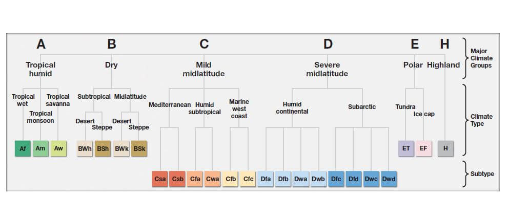
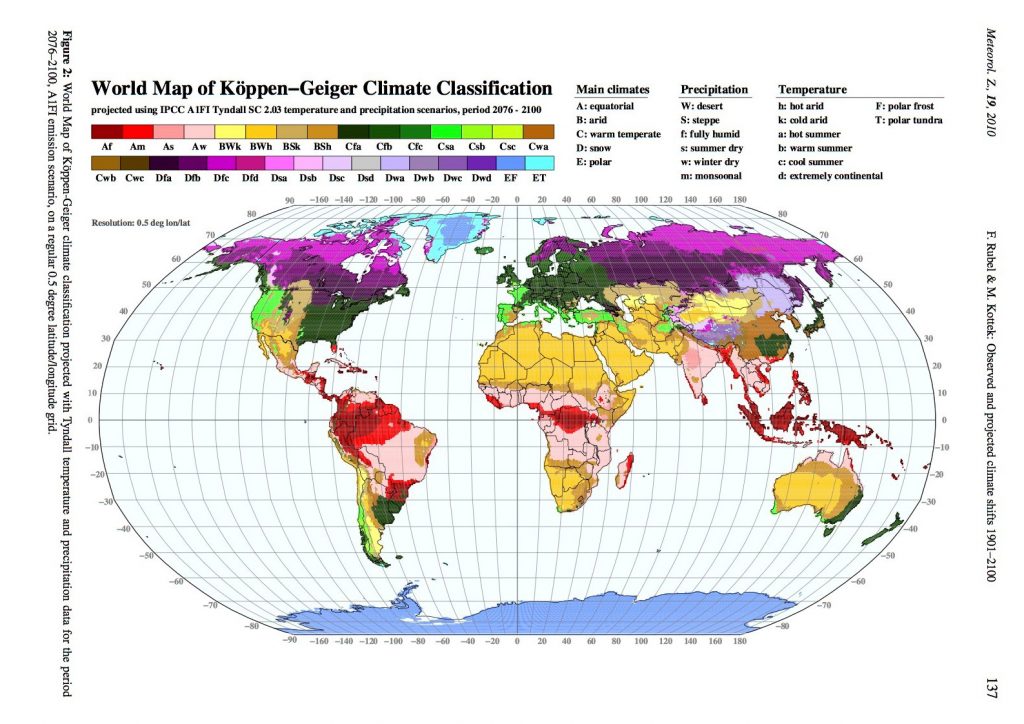
and hekistotherms etc. According to the Köppen Climate Classification, the
global climate can be divided into five primary zones. These climate zones are
based on regional vegetation and defined by the temperature and precipitation
that is responsible for its formation. The zones are defined by the capital
letters A, B, C, D, and E. The climate zones defined by each letter are:
A) Tropical Climates
B) Dry Climates
C) Temperate Climates
D) Continental Climates
E) Polar Climates
Each of the five major climate zones covers a vast
region and is divided into smaller categories to describe the more specific
climate types within each zone.
|
SL
NO |
LETTER |
CLASSIFICATION
|
CHARACTERISTICS
|
|
1 |
A |
Tropical
Climates |
Monthly
average temperature is always above 18 degree, no winter season , warm and
moist conditions throughout the year. |
|
2 |
B |
Dry
Climates |
It
represents dry climates where evaporation exceeds precipitation and there is
constant water deficit throughout the year |
|
3 |
C |
Temperate
Climates |
It
represents humid mesothermal or middle latitudes warm temperate climates
having mild winters, average temperature of the coldest and warmest months
between 8 degrees and 18 degrees and below 18 degrees respectively. |
|
4 |
D |
Continental
Climates |
It
included humid microthermal or cold forest climates characterized by severe
winters , average temperature of coldest and warmest months being 3 degree
and above 10 degree respectively |
|
5 |
E |
Polar
Climates |
It
includes polar climates characterized by summerless seasons, average
temperature of the warmest months below 10 degree. |
Besides these capital letters, koppen has used the
following small letters in the scheme for specific meaning
|
f |
Full
year precipitation |
|
m |
Monsoon
climate |
|
w |
Winter
dry season |
|
S |
Summer
dry season |
A) Tropical Climates
Tropical (also known as equatorial)
climates occur in regions situated around the equator and expand to latitudes
of 15° to 25° to the north and south.
It can be defined by the following
characteristics:
•It is the warmest of all the climate
zones.
•Regions in this zone have an average
monthly temperature of higher than 18° Celsius (64.4° Fahrenheit.)
•Annual precipitation exceeds 1 500
millimeters in this zone.
•High humidity levels and warm
temperatures result in a frequent, almost daily occurrences of cumulus or
larger cumulonimbus cloud formations.
This zone is divided into three
subcategories, which are classified according to temperature and dryness.
Af= Tropical rainforest climate: The
climate is characterized by rainfall throughout the year with average
precipitation of at least 60 mm in every month. Because of hot and wet
conditions throughout the year, tropical rain forests occur in this part of the
earth. Towns such as Kishangani in (Congo), Singapore and Hawai (USA) are the
typical examples of the climate.
Am= Tropical monsoon climate: This type
of climate is characterized by short dry season registering less than 60 mm
precipitation in driest month. Rainfall occurs excessively during summer rainy
season making land surface moist throughout the year. Consequently, it supports
the growth of dense forests which shed their leaves in dry season. It is
typical of monsoon climate. Abidjan (Ivory Coast), Jakarta (Indonesia), Yangon
(Myanmar) and Chittagong (Bangladesh) are typical examples of the climate.
Aw or As = Tropical wet and dry or savanna
climate: This type of climate is known as tropical Savana or Grassland. Winter
season in (Aw) climate is usually dry while summer season is dry in (As)
climate. The amount of precipitation in driest month is less than 6 cm. The
water balance remains in deficit during dry season and surplus during wet
season. In terms of vegetation, tall grasses with scattered trees around are
the common sight in this type of climate. Mumbai (India), Dhaka (Bangladesh),
Dar es Salam (Tanzania), Darwin (Australia) and Ho Chi Minh City (Vietnam) are
typical examples of winter dry (Aw) climate and Chennai (India) is a typical
example of summer dry (As) climate
B) Dry Climates Dry (or arid)
Climates occur in regions situated at latitudes
between 20° to 35° north and south of the equator.
It can be defined by the following characteristics:
•The main feature of this climate zone is the complete
absence or extremely low levels of annual precipitation.
•The very dry atmospheric conditions are the result of
the combined evaporation and transpiration levels exceeding the total amount of
precipitation.
•Vegetation is sparse or completely absent as a result
of the dry climate with very little precipitation.
This climate zone is divided into desert (BW) and
semi-arid (BS) regions, according to vegetation type. It is further categorized
into hot (h) and cold (k) zones:
BWh: These are low latitude hot deserts.
Atmospheric conditions are hot and dry with an average annual temperature above
180 C. Khartoum (Sudan), Doha (Qatar), and Death Valley (USA) are examples of
the climate.
BWk: These are mid latitude cold deserts.
Atmospheric conditions are cold and dry with average annual temperature less
than 180 C. Turpan (China), and Nukush (Uzbekistan) are typical examples of the
climate.
BSh: These are semiarid tropical steppe
climates where average annual temperature is more than 180 C. These climates
are usually found in the neighborhood of hot desert. Lahore (Pakistan), Odessa
(USA) and Niamey (Niger) are the examples of the climate.
BSk: These are temperate steppe climates
where average annual temperature is less than 180 C. These climates are usually
found in the proximity of cold deserts. Baku (Azerbaizan), Denver (USA), Lhasa
(China) and Ulanbaatar (Mongolia) are examples of the climate.
C) Temperate Climates Temperate (or
mesothermal)
climates occur in regions situated at latitudes
between 30° to 50° north and south of the equator.
It can be defined by the following characteristics:
•Regions in this climate zone typically experience
warm summers with high levels of humidity and mild winter seasons.
•During the
year, the warmest month is at least 10° Celsius (60° Fahrenheit) or higher,
while the coldest month is lower than 18° Celsius (64.4° Fahrenheit) but higher
than -3° Celsius (26.6° Fahrenheit).
•These climate zones are typically located on the
edges of continents, along the eastern and western coastlines.
Temperate climate zones are divided into three main
categories according to precipitation: mild temperate dry winters (Cw), mild
temperate dry summers (Cs), and mild temperate humid (Cf) climates. All three
subcategories are further divided according to temperatures:
Cfa: These are subtropical wet climates.
Precipitation occurs throughout the year. It is characterized by long and hot
summer season. The average temperature of the hottest month is 220 C and above
and at least four months averaging above 100 C. As compared to it, winter
season is shorter and temperatures do not reach the extreme. Buenos Aires
(Argentina), Srinagar (India), Shanghai (China) and Osaka (Japan) are examples
of the climate.
Cfb: It is a temperate marine climate with
adequate precipitation in all the seasons. Summer season is usually warmer.
However, temperature of the hottest month is less than 220C. Coldest month
averaging above 0 0 C. Winter season is marked with normal temperature
conditions. Paris (France), Amsterdam (Netherlands), Port Elizabeth (South
Africa) and Melbourne (Australia) are examples of the climate.
Cfc: This is a sub polar marine climate
which is relatively cold in winter season. Summer season is short. The average
temperature for a minimum of four months is around 100C. No significant
precipitation difference between seasons. Unalaska (USA), Punta Arenas (Chile),
and Reykjavik (Iceland) are examples of the climate.
Csa: This type of climate is found in the
interior areas of Mediterranean Sea. Summer season is hot and dry but winter
season is normal and wet. Madrid (Spain), Dushanbe (Tajikistan), Perth
(Australia) and Beirut (Lebanon) are the representative stations of the climate.
Csb: This type of
climate is found in the coastal areas of Mediterranean Sea. It has a short
summer season which is dry and hot. The winter season is usually favorable as
it receives rainfall. The average temperature of the hottest month is less than
220C. Santiago (Chile), Cape Town (South Africa) and San Francisco (USA) are
representative stations of the climate.
Cwa: This is subtropical monsoonal
climate. Summer season is hot and wet. Temperature rises to more than 220C for
at least one month. Winter season is normal and dry. Islamabad (Pakistan), New
Delhi (India), Kathmandu (Nepal) and Hong Kong are the representative stations
of the climate.
Cwb: It is a highland type of climate
where temperature remains less than 220 C in hottest month. Winter season is
cold and dry while summer season is warm and wet.
(D) Continental Climates
Continental
climates typically occur in regions situated at latitudes between 40° and 75°
north and south of the equator. (Although this type of climate is rare in the
Southern Hemisphere.)
It can be
defined by the following characteristics:
•The average temperature of the warmest month is above
10° Celsius (50° Fahrenheit), while the coldest month is below -3° Celsius
(26.6° Fahrenheit).
•This climate type is usually found in the interior of
continents.
•Regions in this zone experience summers with warm to
cool temperatures, while the winters are generally cold.
Continental
climate zones are divided into three main categories according to
precipitation: continental dry summer (Ds), continental dry winter (Dw), and
continental humid (Df) climates. Like temperate climates, they are further
divided according to temperature:
Dfa: This climate is located in the continental areas close
to the polar front zone. The annual range of temperature is high and weather is
highly variable. Summers are warm and winters are cold. Precipitation occurs in
all the months. It is found in central and eastern parts of Eurasia between
forty to fifty-five-degree north. New York City (USA), Almaty (Kazakhstan),
Beijing (China) and Seoul (South Korea) represent the climate.
Dfb: This type of climate is found in eastern Asia, China,
Korea, and Japan. More rainfall occurs in summer season and there is a drier
winter. The climate is generally found between 450 to 600 North latitudes.
Sapporo (Japan) is a typical example of the climate.
Dwa: This is a monsoon influenced hot- summer humid
continental climate. It is commonly found in north eastern U.S.A. and south
Eastern Canada. Both coniferous and deciduous forests are found in this belt.
The climate is characterized by moist continental with short period of summer
dryness. Pyongyang (North Korea) and Tianjin (China) are the typical examples
of the climate.
Dwb: This type of climate is found along oceanic margins of
the continents in higher latitudes. It is wet climate with long dry and severe
cold winter season, short and cold summer season. Vladivostok (Russia), and
Pembina (USA) are representative stations of the climate.
Dwc: It is a sub- arctic climate characterized by long cold
and dry winter season. Summer season is short and mild. Moron (Mongolia) and
Yushu City (China) are examples of the climate.
Dwd: This type of climate is found in the proximity of
Sub-Arctic region. It is characterized by long dry and extreme cold winter
season. Summer season is short and mild warm. Yakutsk (Russia) and Oymyakon
(Russia) are examples of the climate.
Dsa: This type of climate exists only at higher elevations
adjacent to areas with hot summer Mediterranean (Csa) climates. Sanandaj
(Kurdistan-Iran), Hakkari (Turkey) are examples of the climate.
Dsb: It is warm, dry- summer continental climate.
Temperature recorded in coldest month averaging < 00 C, all months with
average temperature 100 C. There is at least three times as much precipitation
in wettest month of winter as in driest month of summer. Sivas (Turkey), Roghun
(Tajikistan), Dras (India) and Bridgeport (CaliforniaUSA) are examples of the
climate.
Dsc: It is warm dry summer subarctic climate. Temperature
recorded in coldest month averaging < 0 0 C and 1-3 months averaging >100
C. There is at least three times as much precipitation in wettest month of
winter as in driest month of summer. Homer (Alaska, USA), Mount Olympus
(Greece) and Handud, (Badkhshan Province, Afghanistan) are examples of this
type of climate.
Dsd: Places with this
type of climate have severe winters, with temperatures in their coldest month
lower than -380C. Seymachan, (Magadan Oblast, Russia) is a typical example of
the climate.
E) Polar Climates
Polar climates are located at latitudes above 70° over
the Arctic, Greenland, and Antarctica. It is characterized by its all
year-round cold temperatures and little to no vegetation.
The following
characteristics define it more precisely:
•The warmest month of the year is below 10° Celsius
(50° Fahrenheit).
•Polar climate regions are extremely dry, with annual
precipitation of less than 25 cm (10 inches).
Polar climates are divided into two categories
according to vegetation:
ET: It is a Tundra type of climate. It is
characterized by short a summer season. The normal temperature of warmest month
ranges between 0 0C to 100C. Stanley (Falkland Islands), Mount Wellington
(Australia) and La Rinkonada (Peru) are examples of the climate.
ETf: This is a polar climate. It
experiences glaciations throughout the year and temperature remains below
freezing point. Mount Fuji (Japan), Nuuk (Greenland) and Esperanza Base
(Antarctica) are examples of the climate.
EF: This type of climate occurs in Antarctica
and inner Greenland. It is also experienced in extremely high altitudes on
mountains. Temperatures never exceed 0 0 C (320 F). Mount Everest (Nepal),
Mount Ararat (Turkey), Vostok station (Antarctica) and Summit Camp (Greenland)
are examples of the climate.
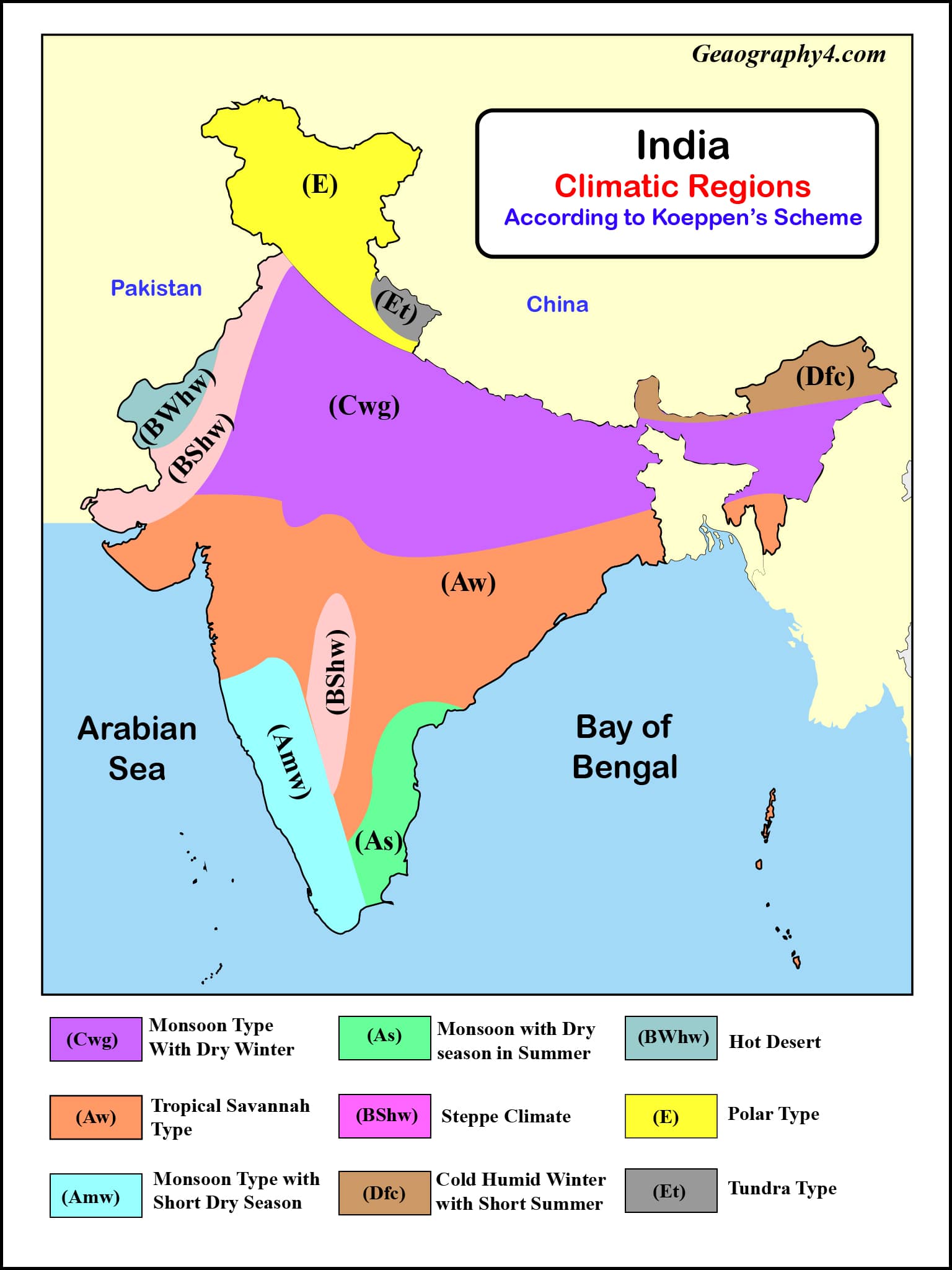
CLASSIFICATION OF KOPPEN IN INDIA
Advantages:
I. Koppen used the temperature and precipitation
statistics in his classification of the climate. These two weather elements are
easy to measure. Because of this quality, these elements are most widely and
most frequently used. Since Koppen's classification is based on statistical
parameters, each climatic region can be precisely defined.
II. Besides, the temperature and precipitation are the
two most effective weather elements that exhibit the effects of climatic
controls more clearly than any other weather elements.
III. These
elements affect other aspects of our physical environment more directly than
any other element. Obviously, the system of classification devised by Koppen is
directly related to those aspects of environment which are clearly visible to
us.
IV. His
climatic classification system is based on the relationship between the types
of plants at a particular place and the climatic characteristics of the place.
Thus, his scheme is not a mere abstraction.
Limitations:
I. There are,
of course, certain drawbacks from which this classification scheme suffers.
Despite the fact that the author himself revised and modified his system
several times, he always felt it to be imperfect. II. Koppen based his
classification on the mean monthly values of temperature and precipitation. By
these statistics the most potent factor of precipitation can only be estimated,
rather than measured accurately.
III. This makes comparison from one locality to
another rather difficult. Further, Koppen did not take into account such
weather elements as winds, precipitation intensity, amount of cloudiness, and
daily temperature extremes only for the sake of making his classification
generalized and simple.
IV. Another
major drawback is that it is empirical and, therefore, is based on facts and
observations. The causative factors of climate have been totally ignored. Thus,
the air masses, which form the very basis of modern climatology, could not find
any place in Koppen's classification.
V. Lastly, the letter symbols used by Koppen in his
climatic classification provide international shorthand describing climatic
regions that are rather difficult to characterize in words.
Conclusion:
As clearly
illustrated throughout this article, several smaller climate regions exist
within each of the five major climate zones. Vegetation, temperature, and
precipitation have been the key factors used in determining each subcategory.
Most countries throughout the world experience multiple sub-climates, and many
larger regions are influenced by five or more different climate types at any
given time. To explain all the climate zones affecting every country/region,
though, will fill an encyclopedia. This post provided a broad and thorough
overview of the five climate regions as defined by the Köppen Climate
Classification. It highlighted the characteristics of each one, as well as
laying out their subcategories and how they were defined.


0 Comments