
CBSE CLASS 9 GEOGRAPHY DRAINAGE SYSTEM IN INDIA QUESTION ANSWER

VERY SHORT ANSWER TYPE QUESTION
Q.1. What does the term ‘Drainage’ mean?
Ans. The term ‘drainage’ describes the river system of an area.
Q.2. What is a ‘drainage basin’?
Ans. The area drained by a single river system is called a drainage basin.
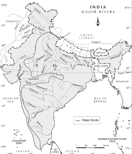
Q.3. Which part of the land is called ‘water divide’?
Ans. Any elevated area, such as a mountain or an upland separates two
drainage basins. Such an upland is known as a ‘water divide’.
Q.4. Into which two major groups are Indian rivers divided?
Ans. The Indian rivers are divided into two major groups
(i) The Himalayan Rivers
(ii) The Peninsular Rivers
Q.5. Which rivers are called perennial?
Ans. Perennial rivers are the ones which have water throughout the year.
These rivers receive water from rain as well as from melted snow from the
lofty mountains.
Q.6. Which river has the largest basin in India?
Ans. River Ganga
Q.7. Why are Peninsular rivers called seasonal?
Ans. A large number of peninsular rivers are seasonal as their flow is
dependent on rainfall and even the large rivers have reduced flow of water in
the dry season.
Q.8. Name the rivers which originate in Central Highlands & flow
towards the west.
Ans. Rivers Narmada and Tapi.
Q.9. What is a river system?
Ans. A river along with its tributaries may be called a river system.
Q.10. From where does river Indus originate?
Ans. River Indus originates in Tibet, near Lake Mansarowar.
Q.11. Which are the main tributaries of river Indus?
Ans. The Satluj, the Beas, the Ravi, the Chenab and the Jhelum are the main
tributaries of river Indus.
Q.12. Name the main tributaries of the river Ganga.
Ans. The Yamuna, the Ghaghara, the Gandak and the Kosi are the main
tributaries of river Ganga.
Q.13. How is Sunderban Delta named?
Ans. The Sunderban delta has derived its name from Sundari trees which
grow well in marshland.
Q.14. By what name is Brahmaputra known in Tibet and
Bangladesh?
Ans. In Tibet it is known as Tsang-Po and in Bangladesh it is called Jamuna.
Q.15. Why does river Brahmaputra carry less water in Tibet?
Ans. In Tibet, the river carries a smaller volume of water & less silt as it is a
cold and a dry area.
Q.16. Name the major Peninsular rivers.
Ans. The Mahanadi, the Godavari, the Krishna and the Kaveri.
Q.17. Which two peninsular rivers form estuaries?
Ans. Narmada and Tapi.
Q.18. Which are the main west flowing rivers of Western Ghats?
Ans. Sabarmati, Mahi, Bharatpuja and Periyar.
Q.19. Which river is the largest Peninsular river?
Ans. The Godavari, its length is about 1500 km.
Q.20. Which river is called ‘Dakshin Ganga’?
Ans. Godavari is called ‘Dakshin Ganga’ because of its length and the area it
covers.
Q.21. What is ‘Shivasamudram’?
Ans. The river Kaveri makes the second biggest waterfall in India.
Q.22. Name some of the freshwater lakes of India.
Ans. The Wular lake, The Dal lake, Bhimtal, Nainital, Loktak and Barapani
SHORT ANSWER TYPE QUESTION
Q.1. What does ‘drainage’ mean? What is a ‘drainage basin’?
Ans. (i) The term ‘drainage’ means the river system of an area.
(ii) Some small streams flowing from different directions come together to
form the main river, which ultimately drains into a large water body. The area
drained by a single river system is called a ‘drainage basin’.
Q.2. From where does the river Indus originate and which tributaries
join the main river?'
Ans. (i) River Indus originates in Tibet near lake &aposMansarovar&apos.
Several tributaries such as the Zaskar, Nubra, Shyok and the Hunza join the
river Indus in Kashmir.
(ii) The Satluj, Beas, Ravi, Chenab and Jhelum rivers join together to enter
the Indus near Mithankot in Pakistan.
Q.3. From where does the river Ganga originate and which
tributaries join it?
Ans. The river Ganga originates from the Gangotri glacier as ‘Bhagirathi’.
Then it is joined by Alaknanda at Devaprayag in Uttarakhand. The Ganga is
joined by many rivers from the Himalayas such as Yamuna, Ghaghara,
Gandak and the Kosi rivers. The river Yamuna originates from the Yamunotri
glacier, but joins the river Ganga at Allahabad. The main tributaries which
come from the peninsular uplands are the Chambal, the Betwa and the Son.
Q.4. Prepare a short note on the ‘Sunderban Delta’.
Ans. (i) The Sunderban Delta is the world’s largest and the fastest growing
delta. (ii) Filled by various tributaries, the river Ganga reaches West Bengal.
(iii) This is the northernmost part of the Ganga Delta. From here, the
Bhagirathi-Hooghly (a distributary) flows southwards towards the deltaic
plains and the Bay of Bengal. (iv) The main stream flows southwards into
Bangladesh and is joined by Brahmaputra, known as Meghna. (v) This mighty
river (with waters from Ganga and Brahmaputra) forms the deltaic plains and
then flows into the Bay of Bengal. (vi) It derives its name from the Sundari
tree which grows in marshland.
Q.5. How does the Brahmaputra river enter India? Which are its
tributaries?
Ans. (i) The Brahmaputra rises in Tibet, near the Mansarovar lake. Then it
flows eastwards, parallel to the Himalayas. On reaching the Namcha Barwa,
it takes a U-turn and enters India into Arunachal Pradesh through a deep
gorge.
(ii) Its tributaries are—the Dihang, the Lohit and Kenula.
Q.6. From where does the river Narmada originate? How is the
Narmada basin formed?
Ans. The Narmada river rises in the Amarkantak hills in Madhya Pradesh.
From here, it flows towards the west in a rift valley. In Jabalpur, it passes
through a deep gorge of ‘marble rocks’. It also forms the ‘Dhunadhar falls’. It
passes through the states of Madhya Pradesh and Gujarat.
Q.7. Prepare a short note on the river Tapti.
Ans. (i) The Tapti rises in the Satpura ranges in Betul district of Madhya
Pradesh.
(ii) It also flows in a rift valley, parallel to the Narmada river.
(iii) Its basin covers parts of Madhya Pradesh, Gujarat and Maharashtra.
Q.8. What do you know about the Mahanadi river?
Ans. (i) The Mahanadi rises in the highlands of Chhattisgarh.
(ii) It flows through Odisha to reach the Bay of Bengal.
(iii) The length of the river is about 860 km.
(iv) Its drainage basin is shared by the states of Maharashtra, Chhattisgarh,
Jharkhand and Odisha.
Q.9. From where does the river Krishna originate and name its
tributaries?
Ans. (i) The river Krishna rises from a spring near Mahabaleshwar.
(ii) The Tungabhadra, Koyna, Ghatprabha, Musi and the Bhima are some of
its tributaries.
Q.10. Write down the differences between a delta and an estuary.
Ans. Delta
(i) It is a triangular-shaped piece of land, formed at the mouth of a river,
where it meets the sea.
(ii) With the continuous deposition of silt on its bed, a river goes on splitting
itself into channels or distributaries. They carry river water into the sea.
(iii) Delta shows an extension of land into sea. It is continuously growing
seawards.
(iv) The sea is shallow. Tidal currents are not strong enough to remove
deposits effectively.
(v) The world’s largest and the fastest growing delta is the Ganga-
Brahmaputra delta known as the Sunderban delta. Peninsular rivers like the
Mahanadi, Godavari, Krishna and Kaveri also form big deltas.
Estuary
(i) An estuary is an inlet formed generally by the submergence of the mouth
of a river.
(ii) It has a single mouth or channel. It has steep banks or slopes. Where an
estuary is formed, sea is deep.
(iii) Strong tidal waves carry away the little amount of sediments deposited
by a river.
(iv) Estuaries produce an indented coastline and provide sites of natural
harbours. They create conditions for better navigation.
(v) The mouths of rivers Narmada and Tapi present good examples of
estuaries.
LARGE ANSWER TYPE QUESTION
Q.1. State some economic benefits of rivers and lakes.
Ans. (i) Water from the rivers is a basic natural resource, essential for
various human activities.
(ii) The river banks have attracted settlers from ancient times. These
settlements have now become big cities.
(iii) Using rivers for irrigation, navigation, hydro-power generation is of
special significance.
(iv) Rivers are very significant for countries like India where agriculture is the
livelihood for a majority of the population.
(v) Lakes help to develop tourism and provide recreation.
Rivers have been of fundamental importance throughout human history.
Q.2. Define the following drainage patterns: Dendritic, Trellis,
Rectangular and Radial.
Ans. (i) Dendritic: The dendritic pattern develops where the river channel
follows the slope of the terrain. The stream with its tributaries resembles the
branches of a tree.
(ii) Trellis: A river joined by its tributaries at approximately right angles
develops a trellis pattern. A trellis drainage pattern develops where hard and
soft rocks exist parallel to each other.
(iii) Rectangular: A rectangular drainage pattern develops on a strongly
joined rocky terrain.
(iv) Radial: A radial pattern develops when streams flow in different
directions from a central peak or dome-like structure.
Q.3. What types of lakes are found in India? Give suitable examples.
Ans. India has many lakes. They differ in size and other characteristics. Most
lakes are permanent, whereas some contain water only during the rainy
season. There are lakes which are formed by the action of glaciers and ice
sheets, while the others have been formed by human activities.
(i) Salt water lakes: Spit and bars form lagoons or salt water lakes in the
coastal areas like the Chilika lake, Pulicat lake and the Kolleru lake.
Sometimes, salt water lakes are formed with island drainage like Sambhar
lake in Rajasthan. Its water is used for producing salt.
(ii) Freshwater lakes: Most of these are in the Himalayan region. They are
of glacier origin. They are formed when glaciers dug out a basin, which was
later filled with snow melt. The Wular lake in Jammu and Kashmir is the
largest freshwater lake in India. Other freshwater lakes are the Dal, Bhimtal,
Nainital, Loktak and Barapani.
(iii) Man-made lakes: The damming of the rivers for the generation of
hydel power has also led to the formation of lakes. These lakes are formed to
drain excessive water of the river during floods and adding water to the
rivers during the dry season. Such lakes are the Guru Gobind Sagar (Bhakra
Nangal Project), Nizam Sagar, Nagarjuna Sagar, Rana Pratap Sagar, etc.
Q.4. Give characteristics of the Ganga-Brahmaputra river system.
Ans. The basin is separated from the Indus by the watershed in Haryana,
i.e., Ambala. It covers the Central and the Eastern parts of the northern
alluvial plains in Haryana, U.P., West Bengal and Assam. Its large central part
is drained by river Ganga and its many tributaries. The general slope of the
Ganga plain is from the north-west to south-east and south into Bay of
Bengal. Its eastern part is drained by the mighty Brahmaputra river. It slopes
from the north-east to south-west and then southward into Bangladesh.
Q.5. Write main features of Indus Basin.
Ans.
The river Indus rises in Tibet, near lake Mansarovar.
Flowing west, it enters India in the Ladakh district of Jammu & Kashmir.
It forms a picturesque gorge in this part.
It flows through Baltistan and Gilgit and emerges from the mountain at
Attock.
All its major tributaries—the Satluj, the Beas, the Ravi, the Chenab and
the Jhelum—join together to enter the Indus near Mithankot in
Pakistan.
Beyond this, the Indus flows southwards eventually reaching the
Arabian Sea, east of Karachi. Indus is 2,900-km long and is one of the
longest rivers of the world.
Q.6. Give main characteristics of the Ganga River System.
Ans.
The headwaters of the Ganga called the ‘Bhagirathi’ is fed by the
Gangotri Glacier and joined by Alaknanda at Devaprayag in
Uttarakhand.
At Haridwar, the Ganga emerges from the mountains on to the plains.
Its tributaries are flood parts of the northern plains every year, causing
widespread damage to life and property but enriching the soil for the
extensive agricultural lands.
Enlarged with the waters from its right and left bank tributaries, the
Ganga flows eastward till Farakka in West Bengal. This is the northern
most point of Ganga Delta.
The mainstream flows southwards into Bangladesh and is joined by the
Brahmaputra. This mighty river along with Brahmaputra flows into the
Bay of Bengal and the delta formed by these rivers is known as
Sunderban delta.
Q.7. What are the main characteristics of the mighty river
Brahmaputra?
Ans.
The Brahmaputra rises in Tibet east of Mansarovar Lake, very close to
the sources of the Indus and the Satluj.
It is slightly longer than the Indus and most of its course lies outside
India.
In Tibet, the river carries a smaller volume of water and less silt as it is
a cold and a dry area.
In India, it passes through a region of high rainfall. Here the river
carries a large volume of water and considerable amount of silt.
The Brahmaputra has a braided channel in its entire length in Assam
and forms many riverine islands.
Every year during the rainy season, the river overflows its banks
causing widespread devastation due to floods in Assam and
Bangladesh.
Unlike other north Indian rivers, the Brahmaputra is marked by huge
deposits of silt on its bed causing the river bed to rise. The river also
shifts its channel frequently.
Q.8. Give main characteristics of the largest peninsular river.
Or
Which river is known as ‘Dakshin Ganga’? State any two
characteristics of it.
Ans. (i) The Godavari is the largest peninsular river.
(ii) Its length is about 1500 km. Its drainage basin is also the largest
amongst the peninsular rivers.
(iii) The basin covers the parts of Maharashtra, Madhya Pradesh, Odisha and
Andhra Pradesh.
(iv) The Godavari is joined by a number of tributaries such as the Purna, the
Wardha, the Pranhita, the Manjra, the Wainganga and the Penganga.
(v) The last three tributaries are very large. Because of its length and the
area it covers, it is also known as ‘Dakshin Ganga’.
Q.9. How do Indian lakes differ from each other?
Ans. India has many lakes. These differ from each other in size, and other
characteristics. Most lakes are permanent; some contain water only during
the rainy season, like the lakes in the basins of inland drainage of semi-arid
region. There are some of the lakes which are the result of the action of
glaciers and ice sheets, while the others have been formed by wind, river
action and human activities.
Q.10. Describe the journey of river Ganga in India and which rivers
join it en route.
Ans.
The river Ganga originates from Gangotri Glacier and is called
Bhagirathi over here.
It is joined by Alaknanda at Devaprayag in Uttarakhand.
At Haridwar, it enters the plains and starts doing the job of
transportation and deposition.
The major Himalayan rivers joining Ganga are the Yamuna, the
Ghaghra, the Gandak and the Kosi.
The river Yamuna flows parallel to the Ganga and as a right bank
tributary meets the Ganga at Allahabad.
The Ghaghra, the Gandak and the Kosi originate from Nepal Himalayas
and ultimately join river Ganga.
These rivers flood northern plains almost every year causing
widespread damage to life and property but enriching the soil for the
extensive agricultural land.
The tributaries coming from the peninsular uplands are the Chambal,
the Betwa and the Son.
Enlarged with waters from its right and left bank tributaries, the Ganga
flows eastwards till Farakka in West Bengal. This is the northern most
point of the Ganga Delta.
The river bifurcates here; the Bhagirathi—Hooghly flows southwards
through the deltic plains to the Bay of Bengal. With Brahmaputra, it
forms the world’s biggest delta called the ‘Sunderbans Delta’. Here,
ends the journey of river Ganga.
Q.1. Explain the term ‘water divide’ with example. What is its
significance?
Ans. (i) Any elevated area such as a mountain or a plateau that separates
two drainage basins is known as a ‘water divide’.
(ii) For example, Ambala is located at the water divide between the Indus
and Ganga rivers. It does not receive water from either of the two rivers.
Q.2. Why do Himalayan rivers get flooded every year? What are its
advantage?
Ans. Himalayan rivers get flooded every year due to excessive melting of
the snow due to global warming and excessive rains too.
Advantage:
(i) They enable the enriching of the soil in entire northern plains by providing
alluvial silt to it.
(ii) Various food and cash crops are grown in it and due to irrigational
facilities and green revolution, certain crops have bumper crops.
Q.3. Explain any three differences between east flowing peninsular
rivers and west flowing peninsular rivers.
Ans. The East flowing rivers:
(i) These rivers originate from the Western Ghats and flow eastwards.
(ii) They all form deltas at their mouths.
(iii) They drain into the Bay of Bengal.
(iv) They have large volume of water.
Examples: Mahanadi, Godavari, Krishna and Kaveri
The West flowing rivers:
(i) These rivers originate in Central India and flow westwards.
(ii) They form estuaries since they flow from rift valleys.
(iii) They drain into the Arabian Sea.
(iv) They have lesser volume of water.
Examples: Narmada and Tapi
Q.4. ‘Lakes are of great value to human beings’. Justify the
statement with three suitable reasons.
Ans. The benefits of lakes to human beings are:
(i) A lake helps to regulate the flow of a river.
(ii) During heavy rainfall, it prevents flooding and during the dry season, it
helps to maintain an even flow of water.
(iii) Lakes can be used for developing hydel power too.
(iv) They help in maintaining a moderate climate.
(v) They are able to maintain the aquatic ecosystem.
(vi) They enhance the natural beauty and help in developing tourism and
provide recreation.
Q.5. How do urbanisation and industrialisation cause river pollution?
Suggest three measures to control river pollution.
OR
What are the main causes of the pollution in the rivers of India? How
can we prevent this kind of pollution?
Ans. The main causes of pollution of Indian rivers are:
(i) The growing domestic, municipal, industrial and agricultural demand for
water from rivers naturally affects the quality of water.
(ii) As a result, more and more water is drained out of the rivers, thereby
reducing their volume.
(iii) A heavy load of untreated sewage and industrial effluents are emptied
into the rivers.
(iv) This affects not only the quality of water but also the self-cleansing
capacity of the river.
(v) The increasing urbanisation and industrialisation has increased the
pollution levels of the rivers.
How to prevent pollution:
(i) The effluents of the industries should be treated before they enter the
river waters.
(ii) People of the urban areas living on the banks of the rivers should be
sensitised about the pollution levels of the rivers and the difficulty in
cleaning it.
(iii) Since Indians are religious-minded and most of their festivals are
associated with pure water of rivers, the immersing of deities, and of
religious goods and even the dead are associated with these holy rivers,
resulting into pollution, which needs to be checked and controlled


0 Comments