
NEW INDIA FOREST POLICY

The first National Forest Policy (NFP) in independent India came into effect in 1952. Thereafter, in 1988, a new version of the NFP came into being.
Its Objectives are:
1. Maintenance of environmental stability” through preservation and restoration of ecological balance.
2. Conservation of natural heritage;
3. Checking soil erosion and denudation in catchment areas of rivers, lakes and reservoirs;
4. Checking extension of sand dunes in desert areas of Rajasthan and along coastal tracts;
5. Substantially increasing forest/tree cover through massive afforestation and social forestry programmes;
6. Taking steps to meet requirements of fuel, wood, fodder, minor forest produce, soil and timber of rural and tribal populations;
7. Increasing productivity of forests to meet the national needs;
8. Encouraging efficient utilisation of forest produce and optimum substitution of wood; and
9. Taking steps to create massive people’s movement with involvement of women to achieve the objectives and minimise pressure on existing forests.
FOREST SURVEY REPORT 2021
1.The National Forest Policy of India, 1988 envisaged a goal of achieving 33 per cent of the geographical area of the country under forest & tree cover.
2.India State of Forest Report (ISFR)i is a biennial publication of Forest Survey of India (FSI), an organization under the Ministry of Environment, Forest and Climate Change, Government of India.
3.On January 13,2022, the Minister for Environment, Forest and Climate Change (MoEFCC), Shri BhupenderYadav, released the ‘India State of Forest Report 2021’iii prepared by the Forest Survey of India (FSI). The India State of Forest Report 2021 provides information on forest cover, tree cover, mangrove cover, growing stock, carbon stock in India’s forests, forest fire monitoring, forest cover in tiger reserve areas, above ground estimates of biomass using SAR data & climate change hotspots in Indian forests.
4.New Initiatives and Features of the ISFR 2021
In the present ISFR 2021, FSI has included a new chapter related to the assessment of forest cover in the Tiger Reserves, Corridors and Lion conservation area of India.
A new initiative of FSI has also been documented in the form of a chapter, where the ‘Above Ground Biomass’ has been estimated. FSI, in collaboration with Space Application Centre (SAC), ISRO, Ahmedabad, initiated a special study for estimation of Above Ground Biomass (AGB) at pan-India level, using L- band of Synthetic Aperture Radar (SAR) data.
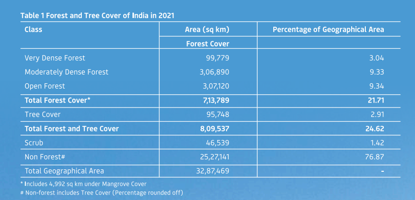
5.The total forest and tree cover of the country is 80.9 million hectare which is 24.62 percent of the geographical area of the country. As compared to the assessment of 2019, there is an increase of 2261 sq km in the total forest and tree cover of the country. Out of this, the increase in the forest cover has been observed as 1540 sq km and that in tree cover is 721 sq km. To see the forest cover in the States & UTs of the country as per the 2021 assessment and change therein with respect to the previous assessment (2019)
Increase in forest cover has been observed in open forest followed by very dense forest. Top five states showing increase in forest cover are Andhra Pradesh (647 sq km) followed by Telangana (632 sq km) and Odisha (537 sq km), Karnataka (155 sq Km) and Jharkhand (110 sq. Km).


Area-wise, Madhya Pradesh has the largest forest cover in the country followed by Arunachal Pradesh, Chhattisgarh, Odisha and Maharashtra. In terms of forest cover as percentage of total geographical area, the top five States are Mizoram (84.53 per cent), Arunachal Pradesh (79.33 per cent), Meghalaya (76.00 per cent), Manipur (74.34 per cent) and Nagaland (73.90 per cent).

17 states/UT’s have above 33 per cent of the geographical area under forest cover. Out of these states and UTs, five states/UTs namely Lakshadweep, Mizoram, Andaman & Nicobar Islands, Arunachal Pradesh and Meghalaya have more than 75 percent forest cover while 12 states/UTs namely Manipur, Nagaland, Tripura, Goa, Kerala, Sikkim, Uttarakhand, Chhattisgarh, Dadra & Nagar Haveli and Daman & Diu, Assam, Odisha, have forest cover between 33 percent to 75 percent.

Tree Cover (small patches outside the forests) of the Country is on the rise. The tree cover of the country is estimated to be 95,748 sq km which is 2.91 percent of the geographical area. There is an increase of 721 sq km in the tree cover of the country as compared to assessment of 2019.
Total Forest and Tree Cover is nearing one-fourth of the total geographical area of the country- The Total Forest and Tree Cover gives a complete picture of all forests and tree resources of the country.The total Forest and Tree cover of the country as per the current assessment is 8,09,537 sq km which is 24.62% of the geographical area of the country. Total forest and tree cover of the country has increased by 2261 sq km as compared to the last assessment..
.png)
The country’s forests & Trees Outside Forests (TOF) are better stocked as compared to the last assessment. The total growing stock of wood in the country is estimated as 6167.50 million cubic metres out of which 4388.15 million cubic metres is inside forest areas and 1,779.35 million cubic metres is outside recorded forest areas (TOF). There is a total increase of 251.74 million cubic metres (4.26 per cent) in total growing stock of the country as compared to previous assessment reported in ISFR 2019. Out of this, the increase in growing stock inside the forest is 114.68 million cubic metres (2.68 per cent) and 137.06 million cubic metres (8.35 per cent) outside the forest area.
The Stock of Bamboo in the country has increased. The total number of bamboo culms has increased by 13,882 million as compared to the assessment of 2019. The total estimated green weight of bamboo culms at national level is 402 million tonnes. The present assessment observed an increase of about 124 million tonnes equivalent green weight of bamboo as compared to the previous assessment.
Total mangrove cover in the country is 4992 sq km. An increase of 17 sq Km in mangrove cover has been observed as compared to the previous assessment of 2019.Top three states showing mangrove cover increase are Odisha (8 sq km) followed by Maharashtra (4 sq km) and Karnataka (3 sq km).
Total carbon stock in country’s forest is estimated to be 7204 million tonnes and there an increase of 79.4 million tonnes in the carbon stock of country as compared to the last assessment of 2019. The annual increase in the carbon stock is 39.7 million tonnes.
Forest Fire Prone Areas Mapping - Severe fires occur in many forest types particularly dry deciduous forests, while evergreen, semi-evergreen and montane temperate forests are comparatively less prone. FSI has been monitoring forest fire since 2004.
Total Fire prone forest area is 35.47 per cent of the forest cover as per current assessment.
Assessment of Forest Cover and decadal change in 52 Tiger Reserves and Lion Conservation Area of India.
There are 52 tiger reserves, spread across eighteen major states of the country covering a total notified area of 73,972.50 sq km.
The current assessment shows that the forests cover in the tiger reserves is 55,666.27 sq km, which is 7.80 per cent of the country’s total forest cover and 74.51% of the total area of tiger reserves.
Gir Wildlife Sanctuary (excluding National Park), has 177.60 sq km of grassland whereas Gir National Park has 33.58 sq km of grassland, summing up to 211.18 sq km, which is 26.11 per cent of the area of Gir National Park and WLS.
Mapping of Climate Change Hotspots in Indian Forests -
Mapping of Climate hotspots over the forest cover in India using computer model-based protection of temperature and rainfall data has been carried out for the three future time periods i.e., year 2030, 2050 and 2085. FSI in collaboration with Birla Institute of Technology & Science (BITS) Pilani, Goa Campus has performed this study. The period 2030 represents near-term timeline that coincides with global short-term climate action horizon. Period 2050 represents the mid-term timeline and coincides with global long-term climate action goals. The period 2085 represents the long-term time horizon.
By analyzing all the scenarios in the studied periods i.e., 2030, 2050 and 2085; it has been observed that Ladakh, Jammu-Kashmir, Himachal Pradesh and Uttarakhand are projected to witness highest temperature increase while Andaman & Nicobar Islands, West Bengal, Goa, Tamil Nadu and Andhra Pradesh are Projected to witness the least temperature rise over these periods.
The North-Eastern States and Upper Malabar Coast of India are projected to experience highest increase in rainfall; whereas, part of North-Eastern States like Arunachal Pradesh, Sikkim, North-Western parts of the country Namely Ladakh, Jammu & Kashmir and Himachal Pradesh are projected to experience least increase and even decline in rainfall.
Mapping of Forest Cover in Major Mega Cities
In the current assessment, extent of Forest Cover of seven major cities (as given in the table below) has been measured. The total forest cover in the seven major cities is 509.72 sq km which is 10.21 per cent of total geographical area of the cities. Delhi has the largest forest cover (194.24 sq km) followed by Mumbai (110.77 sq km) and Bengaluru (89.02 sq km.). Hyderabad has shown maximum decadal increase of 48.65 sq km in Forest cover followed by Delhi with an increase of 19.91 sq km.


0 Comments