
Geographic Grid: Latitudes and Longitudes // IMPORTANT QUESTION ANSWER
I. Short Answer Questions
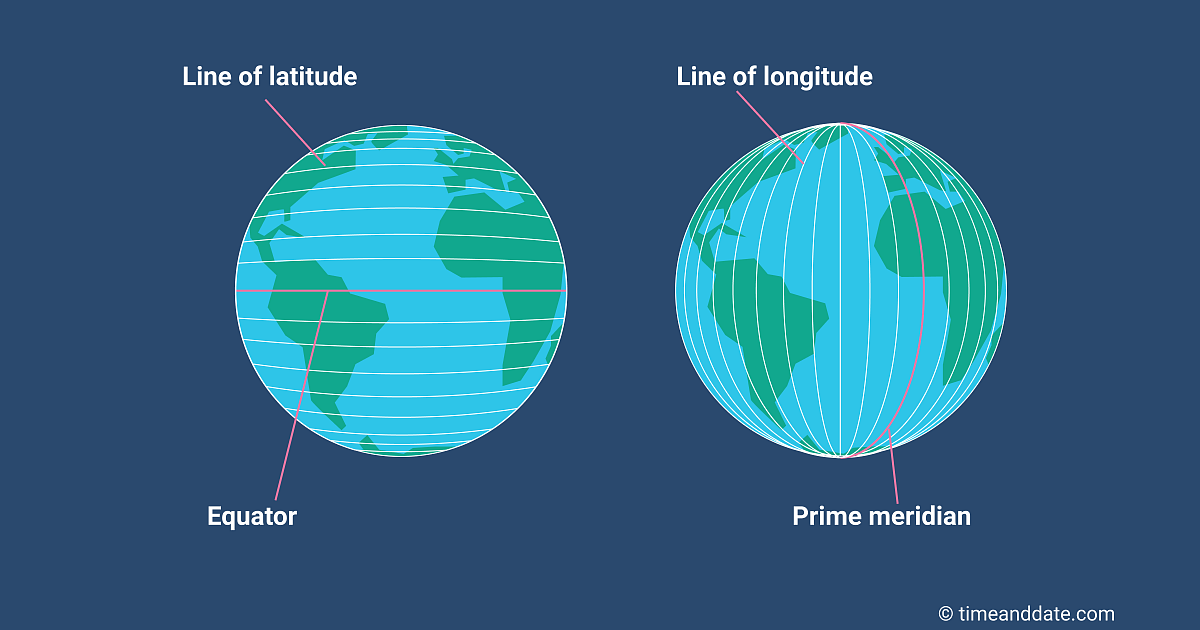
Question 1.What is a geographic grid ?
Answer:The network of the latitudes and the longitudes is known as a geographical grid.
Question 2.Who devised the lines of latitude and longitude ?
Answer:Eratosthenes, the Greek philosopher, first time devised the lines of latitude and
longitude.
Question 3.What are lines of latitude and longitude ?
Answer:The latitudes are the parallel circles with respect to the equator reducing in length
northwards and southwards and the poles are the points only. On the other hand
longitudes are equal in length drawn from North Pole to South Pole with their intervals
reducing towards poles.
Question 4.Mention two characteristics of lines of latitude ?
Answer:(a) The lines of latitude are parallel to the equator.
(b) The lines of latitude are drawn at an angular distance with respect to the equator.
Question 5.Name the two hemispheres of the earth made by the Equator.
Answer:Northern hemisphere and Southern hemisphere.
Question 6.Express 1° angular distance in kilometres.
Answer:As the circumference or the equator is nearly about 40,000 km.
So 1° angular distance in km. will be 40,000/360 =111 km. approximately.
Question 7.Name the thermal zones of the earth.
Answer:The thermal zones of the earth are Tropical, Temperate and Polar zones.
Question 8.With the help of degrees, name the important lines of latitude.
Answer:(a) Tropic of Cancer — 23 1/2°N
(b) Tropic of Capricorn — 23 1/2° S.
(c) Arctic Circle — 66 1/2° N.
(d) Antarctic Circle — 66 1/2° S
(e) North Pole — 90°N
(f) South Pole — 90°S
Question 9.Which temperature zone receives almost vertical rays of the sun and which zones
receive slanting rays ?
Answer:The Tropical zone gets vertical rays of the sun, while temperate and polar zones receive
slanting rays of the sun.
Question 10.Which line is known as the Prime Meridian ? State its importance.
Answer:Greenwich Meridian is called the ‘Prime Meridian’ or the 0° longitude. The time is
calculated with respect to this Meridian. So it is the basic Meridian and time is written as
G.M.T. (Greenwich Meridian Time) The earth takes 4 minutes for moving 1° distance.
Question 11.How can the general climate of an area be described with the help of the lines of
latitudes ?
Answer:The temperature decreases northwards and southwards from the equator. The region
within 23 1/2° N and 23 1/2° S will get tropical climate with ample temperature an rainfall. On the other hand the regions between23 1/2° N – 66 1/2° N and 23 1/2° S – 66 1/2° S will get temperate climate, while the regions known as Arctic and Antarctic circles get very cold polar climate as Tundra region.
Question 12.Which line of longitude is used to fix the World Standard Time ? State its value in
degrees.
Answer:Greenwich Meridian is used to fix the World Standard Time. Its value in degrees is 0°.
This time is written as G.M.T.
Question 13.State the longitudinal value in degrees of Indian Standard Meridian.
Answer:Longitudinal value of Indian Standard Meridian is 82 1/2° E. It passes midway through
India nearly along the city of Allahabad.
Question 14.What is meant by IDL ? State its importance.
Answer:IDL means the International Date Line, which is along 180° E & W. The date or day changes while crossing this line i.e. while there is Monday in the Eastern Hemisphere i.e. 0° – 180°E, there will be Sunday in the Western Hemisphere i. e. 0° – 180° W.
Question 15.What are the Great Circle Routes ? State their importance.
Answer:The Great Circle Routes follow the great circles i. e. the perimeters of the earth, which cover the shortest distances between any two places in spite of the zigzag routes along the surface of earth. These circles are beneficial for following the shortest distances between any two places and help in saving the time. i. e. the shortest routes are covered in minimum time span.
Question 16.What is a globe ? State the importance of a globe.
Answer:A globe is a man-made spherical model of the earth. A globe is very useful model todisplay the actual shape of the earth with its tilted axis ; The rotation and revolution of the earth can be very clearly shown by it along with the continents and oceans.
Question 17.How many lines of latitude are there ?
Answer:180 + 1 = 181
Question 18.How many lines of longitude are there ?
Answer:360 – 1 = 359.
Question 19.Which meridian is called Prime meridian ?
Answer:0° meridian.
Question 20.What is the latitude of equator ?
Answer:0°
Question 21.What is the latitude of Tropic of Cancer ?
Answer:23 1/2° North.
Question 22.What is the latitude of Tropic of Capricorn ?
Answer:23 1/2° South.
Question 23.Which is the longest line of latitude ?
Answer:Equator.
Question 24.Which star is located vertically above the North pole ?
Answer:Pole-Star
Question 25.Into how many time zones, has the world been divided?
Answer:24
Question 26.What do you mean by meridians ?
Answer:Lines of longitude.
Question 27.What is the relation between Temperature and Latitude of a place ?
Answer:The temperature decreases with latitude.
Question 28.What is latitude of North pole and South pole ?
Answer:90° N and 90° S.
Question 29.Why are there 180 parallels of latitude ?
Answer:Because North pole to South pole (a hemisphere) has an angle of 180°.
Question 30.Name the two hemispheres of the Earth made by the equator ?
Answer:Northern Hemisphere and Southern Hemisphere.
Question 31.Which temperature zone receives slanting rays ?
Answer:Polar Zone.
Question 32.Name the two reference lines with respect to which the distances of various places onthe earth’s surface are measured ?
Answer:Prime Meridian and Equator.
Question 33.What is the rate of change of time per degree of longitude ?
Answer:4 minutes per degree.
Question 34.Why are the letters N or S added to latitude values ?
Answer:The latitudes in Northern Hemisphere are marked N while the latitude in Southern Hemisphere marked S.
Question 35.Why are letters E or W added to longitude values ?
Answer:The longitudes in the Eastern Hemisphere are marked E while the longitudes in the Western Hemisphere are marked W.
Question 36.What is the importance of Tropic of Capricorn ?
Answer:It marks the Southern limit of tropical zone.
II. Give reasons for each of the following
Question 1.Lines of latitude carve out the heat zones of the earth.
Answer:The Temperature goes on decreasing from the equator towards the poles. So thelatitudinal zones are the actual heat zones of the earth, namely tropical, temperate andpolar zones.
Question 2.Lines of longitude are also called Meridians of longitude?
Answer:The word ‘meridian’ means related to noon or 12 p.m. As every longitude receives the
noon time or 12 p.m. at different intervals where the sun’s rays are exactly vertical over
a particular longitude. On a particular longitude the noon-time is the same from north to
south ; so a longitude is also called a Meridians of longitude.
Question 3.
Diametrically opposite lines of longitude and the Equator are called Great Circles.
Answer:Every longitude along with its opposite longitude makes a complete circle around the
earth and another complete big circle is the equator; while the latitudes make smaller
circles along with the poles to be only points. So the equator and the longitudinal lines
around the earth are called the Great Circles.
Question 4.
The Greenwich time is called Greenwich Mean Time.
Answer:The time of any place or country is calculated according to the 0° longitude or
Greenwich meridian, the time change is of 4 minutes for every 0° longitude. So it is
called Greenwich Mean Time.
Question 5.IDL deviates and goes zig-zag near some Islands in the Pacific ocean.
Answer:IDL is not a straight line, but it deviates in order to classify some scattered Islands in a
particular divisions of Hemispheres, so that the day and time can be calculated
according to the line, as the natural position of the Islands is haphazard.
Question 6.A globe is the most popular model of the earth.
Answer:As our earth is spherical in shape, so it can be best represented by a spherical model
like a globe. A globe illustrates the position of continents and oceans, the tilted axis of
the earth, its rotation, the sea and air routes etc. So a globe is a perfect model of the
earth.
III. Long Answer Questions
Question 1.Describe the lines of latitude, their importance and use.
Answer:
The face of the earth is divided into various parallel circles with respect to the equator
on both sides at different angular distances. These lines are veiy important to decide the
climate and temperature range of any place or region as the temperature goes on
decreasing from the equator to polewards.
Question 2.
With reference to the International Date Line, state the following:
(a) It is meaning and application.
(b) The important deviations it makes and reasons for the same.
(c) Give an example of how time lost or gained is computed with reference to this line.
Answer:
(a) The time and date changes as we cross the International Date Line i.e. the
navigators or pilots have to loose one day while crossing westwards and gain one day
while crossing eastwards i.e. When one travels from Tokyo to San Francisco on
Monday, he will reach San Francisco on Sunday.
(b) The International Date Line is not a straight line but have some deviations in order to
adjust with the pattern of the landforms and some islands to decide for the time and
date of these places and regions.
(c) If we are moving from Hawaii Islands towards Shanghai on Tuesday, we will reach
there on Wednesday or Thursday probably, but if we are going eastwards from Shangai
to Hawaii islands on Tuesday. We may reach there either on Tuesday or Monday.
Question 3.
Describe the lines of longitude and state their use in relation to distance and time.
Answer:
A longitude is the angular distance of a place east or we§t of the Prime Meridian or 0°
longitude.
The lines of longitude are the great semi-circles joining North pole and South pole and
are equal in length. These are 0° – 180°E and 0° – 180°W longitudes or total 360°. As
the earth takes 24 hours to make a complete rotation along its axis crossing 360° lines
of longitude, so earth takes nearly 4 minutes to move one degree (1 °) longitude or 111
km length or distance. There is difference of time of one hour between 15° interval of
longitudes. According to the clock-time, EGA stands for East-Gain-Add and WLS means
West Lose Subtract. In other words for each 10 longitude towards east 4 minutes are to
be added and towards west for each 1° longitude 4 minutes are to be subtracted.
Question 4.
Make a detailed study of finding time with the help of longitudes. Give one practical
example.
Answer:
Indian Standard Time is based on 82 1/2° E longitude. So if the time in India is 12 noon,
so it will be 6.30 A.M. in England or GMT. The time difference between 0° and 82 1/2° E
will be 82.5 × 4 – 330 minutes or 330 ÷ 60 = 5 1/2 hours. So there is difference of 5 1/2
hours between India and England, as England lies in the west, so the time will be 5 1/2
hours less than India.
IV. Problem Solving
An Example:A cricket match was to be held at Birmingham at 9 a.m. local time. The position of
Birmingham is 5° W. Calculate the time the viewers have to tune their television in Sydney 151°E.
Answer:
The local time at Birmingham is 9 am.
The location of Birmingham is 5° W of Prime Meridian.
The GMT would be 9:20 a.m.
[9.00hrs + (5° × 4min) = 9.00hrs + 20 min = 9.20 a.m. Sydney is located at 151 °E of
Prime Meridian
At any point of time Sydney would be 151 × 4 = 604 min = 10 hrs 4 min ahead of GMT
(Sydney is to the East of the Prime Meridian so local time would be ahead of GMT)
When it is 9:20 a.m. GMT the local time at Sydney would be (9:20 + 10:04) 19:24 hrs or
7:24 p.m.
in order to watch the Brimingham match at Sydney the viewers would have to tune their
televisions at 7:24 p.m. local time.
Answer the following questions
Question 1.
An important programme was to be broadcast from Mumbai at 7.30 p.m. This was
heard by some Indian sailors near Ivory Coast in West Africa at 20°W longitude. What
was the local time there ?
Answer:
According to the Indian Standard Time 7.30 p.m. based on 82 1/2° E. Longitude was the
time at Mumbai. The longitudinal difference between Mumbai and Ivory Coast at 20° W
is 82.5 + 20 = 102.5. So 102.5 × 4 = 410.0 minutes = 6 hours 50 minutes, i.e. the time
will be 6 hours 50 minutes less than 7.30 p.m. So the time will be 12.40 p.m
Question 2.
What is the longitude of a place where the local time 1:15 p.m. when it is 4 a.m. at
Chicago (88°W) ?
Answer:
The time difference between the two places is 9 hours and 15 minutes or 540 + 15 =
555 minutes So the longitudinal difference will be 555/4 = 138.75° degrees. So the
longitude of the required place will be 50° 45′ E i.e. it will cover 88° from west to 0° and
50° 45 east from 0° or Greenwich line.
Question 3.
Calculate the time at Durban (longitude 30°E) when the time is 7.00 a.m. at New York
(75°W).
Answer:
The longitudinal difference between Durban and New York is 30° + 75°= 105°, so the
time will be 105 x 4 = 420 minutes ahead from New York. There is the difference of 420
minutes or 7 hours, or 2 p.m.
Question 4.
Calculate the longitude of a place where the local time is 6.00 a.m., when the time is
9.00 p.m. at New Delhi on longitude 77° E.
Answer:
The time difference between the required place and New Delhi is 6 + 9 = 15 hours, so
the time in minutes =15 × 60 = 900 minutes So the longitudinal difference = 900/4 =
225°. So the place will be in the west 225° – 77° = 148° W.
Question 5.
Calculate the local time at Singapore (104°E) when it is 6.00 p.m. at Greenwich.
Answer:
The longitudinal difference at Singapore and Greenwich is 104°, so the time difference
is 104 × 4 = 416 minutes i.e. 6 hours 56 minutes. So the time at Singapore will be 12.56
a.m.
Question 6.
Calculate the location of a place where the local time is noon when it is 7.30 p.m. at
Greenwich.
Answer:
Time difference is 12 – 7.30 = 4.30 or 4 hours 30 minutes = 240 + 30 = 270 minutes So
the longitudinal difference is 270/4 = 67.5°. So the longitude is 67.5°W or 67 1/2° W.
Question 7.
What is the time and day at Mumbai (73°E) when it is Sunday 10.30 p.m. at Shillong
(92°E) ?
Answer:
The longitudinal difference is 92° – 73° = 19°. So the time difference is 19 x 4 = 76
minutes or 1 hours 16 minutes or the time at Mumbai is 9.14 p.m.
Practice Questions (Solved)
Question 21.
What is meant by “the Parallels of Latitude ?
Answer:
If you examine a globe or map, you will see two sets of lines drawn across it. One set of
lines runs north and south of Equator and Parallel to it. These lines are called Parallels
of a Latitude. The total number of such lines, if drawn at a distance of one degree, from
one another is 180 : 90 North of the equator and 90 South of the equator.
Question 22.
(a) What do you mean by Longitude of a place ? How is longitude of a place determined
?
(b) What is the “Prime Meridian” ?
(c) What is the difference between Prime Meridian and other meridians of longitude ?
(d) Explain how latitudes and longitudes help to determine the position of a place on the
globe ?
(e) Explain how the longitude of a place affects the time.
OR
State the rate of change of time with longitude.
Answer:
(a) Longitude is the distance of a place east and west of the Prime Meridian along a
parallel of latitude. This distance is measured in degrees.
When we say that the Longitude of Delhi is 77° East, we mean that Delhi lies East of the
Prime Meridian and its distance from the Prime Meridian is 77°
The Longitude of a place can be determined by comparing its Local Time with
Greenwich Time. Greenwich Time can be known either by radio or by means of a watch
which keeps Greenwich Time. Captains of ships generally use a Chronometer for this
purpose. A Chronometer is a time piece which keeps accurate time and which is not
affected by change in temperature. Now suppose that when it is 2 p.m. at Greenwich,
another place shows 5 p.m. The difference between the times of two places is 3 hours,
that is 180 minutes. Thus the place is =180 / 4 = 45° away from the Prime Meridian and
since its time is ahead of Greenwich. Its longitude will be 45° East.
(b) The Prime (or First) Meridian is the meridian from which longitude is measured. It is
numbered. 0° longitude. It is the meridian which passes through Greenwich (near
London). Thus the Prime Meridian is also called Greenwich line.
(c) Other meridians of longitude are the lines which join all places having the same
angular distance, east or west, of the Prime Meridian.
(d) The intersection of latitude and longitude points out the exact position of a place on
the earth’s surface. For example London is situated at 51°30’N (latitude) and 0.5 W
(longitude). With the help of these intersecting lines, it is convenient to locate the
position of London on the map. Actually, latitude and longitude are both imaginary lines
drawn on a map or a globe in order to locate the position of a place or a region on the
earth’s surface.
(e) As the Earth rotates from west to east about its own axis, the zone of illumination
moves slowly towards the west. This accounts for variation in the time of Sunrise and
Sunset at different places on the Earth. The Earth takes 24 hours to complete one
rotation. This means that 360 degrees of longitude are covered in a period of 24 hours.
This gives rise to a time difference of [24 × 60/360] or 4 minutes for 1° of longitude. The
time difference is to be added in case of places to the east of a point. In case of places
to the west, the time difference is to be subtracted. It is possible to calculate the time at
a given place A from the time recorded at B and the longitude difference between
stations A and B.
Question 23.
(a) What is “Greenwich Mean Time” ?
(b) How far is it correct to say that local time is the Sun time ?
(c) How can you say that the use of ‘Local Time’ is very inconvenient nowadays in
practical life ?
(d) Why do some countries have many time zones ?
OR
What are ‘Time Zones’ ?
Answer:
(a) Greenwich Mean Time (GMT):- It is based on 0° longitude of a place of this name
near London. GMT is adopted uniformly by all countries to keep time. It forms the basis
of fixing Time Zones.
(b) When the Sun reaches the highest point in the sky, while crossing the meridian of
any place, it is mid-day or 12.00 noon at that place. If watches are adjusted according to
this time, then it will be known as local time. But the highest position of the sun can be
found only on a sunny day. Therefore it is correct to say that local time is the Sun-time.
(c) Use of Local time is very inconvenient now-a-days in practical life, because if we
have to travel through many countries, it will be convenient to us to follow one particular
standard time, according to which we can set our watches with respect to a particular
country and its standard time with reference to Greenwich or Prime Meridian (0°
Longitude) to bring about international uniformity. This is known as Greenwich Mean
Time (GMT). The Indian Standard time is 5 hrs 30 minutes ahead of GMT.
(d) Large countries like Russia, Canada and the United States have vast longitudinal
extent. They do not have a single Standard Time for the whole Country. They have
many time zones, with each time zone covering about 15° of longitude. The erstwhile
Soviet Union had 11 times zones to cover 165° of longitudinal extent. Canada and the
United States have five time zones extending from the Atlantic coast of the Pacific
coast. There is time difference of five hours between the two coasts.
Question 24.
Give reasons for the following :
(a) There are no latitudes higher than 90°N and 90°S.
(b) The opposite meridians of longitude form a Great Circle.
(c) Local time is a theoretical reality, while Standard Time is a practical necessity.
(d) “The International Date Line is not a straight line coinciding with longitude 180
degrees.” Why ?
(e) The distance between two consecutive meridian, is equal to about 111 kilometres
only at the equator.
(f) When it is noon at Cairo (30°E), the local time in New York (75°W) is 5.00 a.m.
(g) All parallel other than equator are not Great Circles.
(h) A person, travelling from Mumbai to London, alters the time on his watch at several
places.
Answer:
(a) The total circumference of a circle is 360° and the distance between the Equator and
the North Pole is one-fourth of the circumference i.e. 90°. So we have 90 latitudes
towards north and 90 towards south, which are denoted as 90° N and 90° S
respectively.
(b) The opposite meridians of longitude form a Great circle because by each of them
the world is divided into two equal parts
(c) Local time may differ from place to place. Therefore, it is only a theoretic reality. On
the other hand, standard time is the same for a particular country. It is a practical
necessity for the sake of uniformity of time.
(d) The International Date Line passes through the Pacific ocean where there are no
land masses. It follows 180° meridian for most of its distance. The date line is zig-zag in
some places to avoid the confusion of time on the same island. It avoids some islands
and deviates from 180°. In Northern Hemisphere, it bends to the West of 180° while in
the Southern Hemisphere it bends Eastwards.
(e) The circumference of the Earth is approximately 40,000 km. It covers ah angle of
360 degrees. The distance between two consecutive parallels of latitude is everywhere
the same. This is because lines of latitude are parallel lines. Therefore one degree of
latitude. = 40,000/360 = 111km (approximately.)
On the other hand, the distance between two consecutive meridians of longitude is 111
km only at the equator and gradually decreases with distance from the equator. This is
because the meridians of longitude converge at the two poles.
(f)
Longitude of Cairo = 30° E
Longitude of New York = 75° W
Difference in Longitude = 30° + 75° = 105°
(Add because Cairo is in the East of Greenwich and New York is in the West of
Greenwich).
∴ Difference in time = 105 × 4 = 420 minutes = 7 hours
As New York is situated in the West of Greenwich, its local time will be behind that of
Cairo. So we subtract.
(h) it is because of change in longitude at several places
Question 25.
What do you mean by the Latitude of place ?
Answer:
Latitude is the distance of a place north or south of the equator along a meridian. This
distance is measured in degree. When we say that the Latitude of Delhi is 28-j North,
we mean that Delhi lies North of the equator and its distance from the equator is 28 1/2.
Question 26.
How are Latitudes measured ?
Answer:
The latitude of a place is the angular distance of the point north or south of the equator
measured in degrees. The equator is taken as 0° latitude. Latitudes are measured from
0 ° to 90° N and 0° to 90° S. The distance from the equator to 90° N covers a distance
of 1/4 of the circumference of the Earth or 140,000 km. One degree of latitude is
equivalent to the length of about 111 km or 69 miles.
Question 27.
Explain why the lines of longitude are called meridians of longitude ?
Answer:
Lines of longitude are lines which join all places having the same angular distance east
or west of the Prime Meridian. All lines of longitude are semicircles of equal length.
Lines of longitude are also called Meridians because all places along a lines of
longitude experience mid-day at the same time.
Question 28.
State two properties of lines of latitude.
Answer:
1. The length of the lines of latitudes decrease with distance from the equator.
2. All lines of latitude are circles parallel to the equator.
Question 29.
State two properties of lines of longitude.
Answer:
1. The distance between two consecutive longitude decreases gradually with
distance from the equator.
2. All lines of longitude are semicircles of equal length.
Question 30.
Clearly distinguish Longitude from Lines of Longitude.
Answer:
Longitude is the distance of a place from the Prime Meridian while lines of longitude are
lines drawn on a map or globe showing the longitude of all the places at the distance
from the Prime Meridian. These lines join the north and south poles and cut the Equator
at right angles.
Question 31.
What do you mean by “Meridians or Lines of Longitude” ?
Answer:
The other set of lines join the north and south poles and cuts the equator at right angles.
These lines are called Lines of Longitude or Meridians. The total number of such lines, if
drawn 1° apart, is 360° – 180° East and 180° West of the Prime Meridian. It should be
noted that 180° East and 180° West in the same lines.
Question 32.
What is the latitude of :
1. Equator
2. North Pole
3. South Pole
4. Tropic of Cancer
5. Tropic of Capricorn
6. Arctic Circle
7. Antarctic circle ? Also give their characteristics.
Answer:
1. Latitude of Equator The latitude of the equator is 0°. Here the days and nights are
equal throughout the year and the rays of the sun fall exactly vertically at noon on
March 21 and September 23.
2. Latitude of North Pole The latitude of the North pole is 90° North because it is
situated north of the Equator at a distance of a quarter of the circumference of the
earth. Here days and nights are of six-months duration.
3. Latitude of South Pole Latitude of the south pole is 90° south, because it is
situated South of Equator at a distance of a quarter of the circumference of the
earth. Here the days and night are of six months duration.
4. The Latitude of the Tropic of Cancer is 23 1°/2 North. Here the rays of the sun fall
vertically at noon on June 21.
5. The Latitude of the Tropic of Capricorn is 23 1°/2 South.
Here the rays of the sun fall vertically at noon on December 22.
6. The Latitude of the Arctic Circle is 66 1°/2 North. Here once the year (June 21) the
day is of 24 hours duration and once in the year (December 22) the night is of 24
hours duration.
7. The Latitude of the Antarctic Circle is 66 1°/2 South. Here once in the year
(December 22nd) the day is of 24 hours duration and once in year (June 21) the
night is of 24 hours duration.
Question 33.
What adjustment has to be made when ships cross the International Date Line ?
OR
Explain why a day appears to be lost in sailing round the world from east to west and
gained when travelling from west to east.
Answer:
The earth rotates on its axis from west to east, hence places in the east have their sun
rise earlier than places in the west. Now if a man travels round the world from east to
west, for every degree of longitude covered; he will have to set back his watch by four
minutes. Thus after covering 360°when he returns to the place from where he started he
will have to set back his watch 360 x 4 / 60 = 24 hrs. Thus he will appear to have lost a
day. When Francis Drake returned to England after circumnavigating the globe, he
thought it was Saturday, where as actually it was Sunday. The reason was that he had
traveled from east to west, and had under calculated a day. On the other hand if a man
travels from west to east, for every degree of longitude covered he will put forward his
watch by four minutes and for 360° he will forward it 24 hrs. When he returns to the
place from where he started he will appear to have gained a day. When Cap. Basil
Hailed reached Manila after circumnavigating the globe, he thought it was Monday;
where as actually it was Sunday. The reason was that he had traveled from west to east
and had over calculated a day.
Question 34.
Define Equator. What is its main function ?
Answer:
Equator is the parallel of zero degree latitude. It is an imaginary circle round the Earth
bisecting it into halves i.e. Northern * Hemisphere and Southern Hemisphere. It serves
as reference line for the location of different places on the earth.
Question 35.
What will be local time at Delhi 77° E longitude when is 3 p.m. at Tokyo 139°E longitude
?
Answer:
Longitude of Delhi = 77°E
Longitude of Tokyo = 139°E
Difference per degree – 139°- 77° = 62°
Difference of time per degree = 4 minutes , Difference between the time of Delhi and
Tokyo = 4 × 62 = 248 minutes = 4 hours 8 minutes
Since Delhi lies west of Tokyo we shall subtract 4 hours 8 minutes from Tokyo time.
Hence local time at Delhi is 10.52 a.m.
Question 36.
What will be the local time at Madras 80°E ? When it is 9 P.M. at New York 74° W ?
Answer:
Longitude of Madras = 80° E
Longitude of New York = 74° W
Difference in Degrees = 80° + 74° = 154°
Difference in time per degree = 4 minutes
Difference between the times of two places = 40 x 154 = 616 = 10 hour 16 minutes
Since Madras lies East of New York, we shall add 10 hours 16 minutes to the local time
of New York. The local time at Madras will therefore, be 7.16 A.M. next morning.
Question 37.
“The degree of longitude decreases in length poleward”. Why?
Answer:
Equator is the longest parallel on the Earth. All other parallels become shorter
polewards due to spherical shape of the Earth. So the meridians near the poles have a
narrow space. One degree of longitude is the longest at the equator (111 km) at 45°
latitude it is 79 km, at 60° latitude it is 55 km and at poles, it is zero km.
Question 38.
What is the relation between longitude and time ?
Or
“There is a difference of 4 minutes of time for one degree of longitude”. Why ?
Answer:
There is a close relation between longitude and time. The Earth makes one complete
rotation of 360 degrees in 24 hours. It passes through 15 degrees is one hour or one
degree in four minutes. Thus, there is a difference of 4 minutes of time for one degree of
longitude. As the Earth moves from West to East, the places East of Greenwich gain
time whereas the places West of Greenwich loose time.
Question 39.
“Lines of latitude are called parallels of latitude” Why?
Answer:
Lines of latitudes join the places of same latitude. These are circles drawn round the
earth, parallel to the equator. Therefore, these are called parallels of latitude.
Question 40.
A ship crossing international date line at mid-night on Wednesday Eastwards, find that it
is mid-night Tuesday on American side. Why ?
Answer:
A ship crossing international date line from West to East gains a day. It repeats a day. A
day is subtracted from the calendar. So when it is Wednesday mid-night on Asiatic side,
it is Tuesday midnight on the American side.
Question 41.
Mid-days Sun can be seen overhead in Chennai twice a year, but not even once in
Delhi. Why ?
Answer:
Tropic of Cancer is the Northernmost limit of overhead Sun. Sun’s rays do not fall
vertical beyond 23 1/2° N latitude. Delhi is located North of Tropic of Cancer, so the Sun
is never overhead at Delhi. But Chennai has overhead Sun twice a year.
1. When the Sun moves northward, from equator to Tropic of Cancer, the Sun is
overhead at Chennai.
2. When the Sun shifts from Tropic of Cancer to equator, then again Chennai has
overhead Sun.
Question 42.
Explain why there is no higher latitude other than 90° N and 90° S.
Answer:
Latitude is the angular distance from the plane of the equator. All of surfaces (planes) or
circles make a maximum angle of 90° from the plane of the equator. Therefore,
maximum latitude is 90° N in the Northern Hemisphere and 98° Southern Hemisphere.
Question 43.
Name the five important parallels of latitude.
Answer:
(a) Equator is the starting line for all the parallels. It is zero degree parallel.
(b) Tropic of Cancer – 23 1/2° North parallel.
(c) Tropic of Capricorn – 23 1/2° South parallel.
(d) Arctic circle – 66 1/2° North parallel.
(e) Antarctic circle – 66 1/2° South parallel.
Question 44.
(a) What do you mean by local time ?
(b) What is the local time when it is noon at a place ?
(c) What are the main characteristics of local time ?
Answer:
(a) Local time : The local time of a place is the time of its own meridian. The local time is
calculated by the position of the Sun at noon at a given place. When the Sun at any
place is highest in the sky. It is noon.
(b) It is 12 o’clock. All the watches of that place should be set according to that time.
(c) Characteristics :
1. Every meridian has a different local time.
2. The places on the same meridian have the same local time.
3. The Eastern places will be ahead of Western places for local time.
4. Sundial was a simple and old method to determine local time.


0 Comments